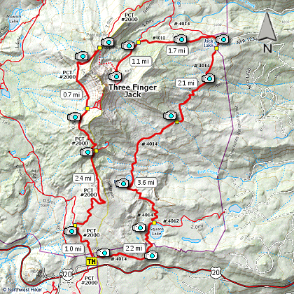
Length: 20 mile loop
Elevation Change: 2600' cumulative elevation gain
Season: Summer thru Fall
Difficulty: Very Difficult, due to distance
Permit: NWF Pass Required
GPS:
Latitude: 44.4255
Longitude: -121.8493
Features:
The trailhead for this hike is located just
off US20 at Santiam Pass. It is well marked.
This is not your normal every day hike to Three
Fingered Jack. In spite of this hikes rather
significant length, one can do this is a day,
as I did, but by taking your time, getting and
early start, and not worrying about driving home
in the dark.
This is an excellent cruise hike. What I mean
is that it seldom gets very steep, and the trail
is in excellent condition. I did the hike
counter clockwise. I recommend this for photography.
Unfortunately, there was a terrible fire through this
area about 3 years ago, leaving 2/3 of the hike within
the burn area. On the plus side, you get better views
than if you were in dense forest, and the wildflowers
are doing great!
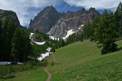
When you finally get to the northeastern base of
Three Fingered Jack, there is a great users trail
that takes you along the moraine with a view of
the little pond still within it. From the ridge
you get great views north toward Mt. Jefferson.
One can easily scramble cross country to meet up
with the Pacific Crest Trail which is plainly visible
from the base of Three Fingered Jack. The trees are
sparse, but the terrain is a bit steep. But only
for a short distance.
Once upon the Pacific Crest Trail it is just a
matter of wearing your boots out on the 9.5 mi
return trip to your vehicle. Although, the
scenery is so great you probably won't mind.
This hike is not for faint hearted. It is long.
Take plenty of water, and rest often.
Trail approaching 3 Fingered Jack
|