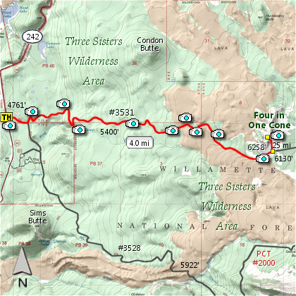
Length: 8.5 miles round trip
Elevation Change: 1497' elevation gain
Season: Summer thru Fall
Difficulty: Challenging
Permit: NW Forest Pass Required
Features:
Here is a great hike with great rewards.
This is the same trailhead as the loop hike
to Obsidian Basin, but much shorter.
If you stay strictly on this trail to the
4 Cones, you will not need the Special Use
Permit that you would need if you were to
cross over into the Obsidian Basin area.
The hike is a gentle climb almost the entire
distance with a few small exceptions. The
trail is almost entirely within forested areas
until you reach the intense lava flows. Here
things really change.
Actually, it is the lava flow areas that make
this hike the excellent hike that it is. Just
a little over two miles into the hike the trail
begins to wind around, over, and between large
lava flows of exceptional interest.
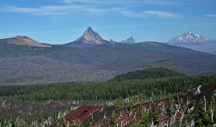
As you approach the 4 Cones area, things really
get interesting. Don't be surprised if you find
snow along the trail even in late summer. The
cutoff trail that takes you to the top of the
4 Cones is located in a flat volcanic area with
excellent views to the southeast of the North
and Middle Sister.
It is a short but steep climb to the top of
the 4 Cones, but OH SO WORTH IT. Here you not
only get superb views of the Sisters to the
southeast, but looking north you see Mt. Washington,
3 Fingered Jack, Mt. Jefferson, and even a little
of Mt. Hood, peeking around the eastern flank of
Jefferson.
This is a fun and rewarding hike. Enjoy!
f="cougars.html">Cougar Encounters
River Crossing Safety
|