

|
THE FOLLOWING MAP IS NOT TO BE USED FOR NAVIGATIONAL PURPOSES.
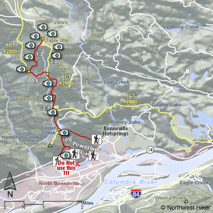
Map of Table Mountain Hike
|
Length: 8 miles with loop
Elevation Change: 3200' gain
Season: Late spring
thru fall
Difficulty: Very Difficult due to length of hike and elevation gained
Permit: No Pass Required unless you start at Bonneville Dam TH
GPS: N45 39.8934, W121 57.573
Latitude: 45.66489
Longitude: -121.95955
Features:
This is a hike that I've always promoted begining at the Bonneville
Dam trailhead. However, since I hiked this hike from the same
trailhead as Aldrich Butte, well, I just don't see any sense in
telling hikers that the only way to hike this mountain is the hard way.
There are those who feel as though we might be tresspassing by approaching
either Table Mountain or Aldrich Butte from the powerline road, but I see
this hike promoted by those who have businesses in the gorge, so I would
imagine as long as we are civil and leave no debris, all will be well.
Having said that, let's talk about the hike.
The beginning of this hike from the powerline road is on an old
abandoned road. Over time this road has been rutted and overgrown
but still represents an excellent approach to Table Mountain.
At about three quarters of a mile you will see the road to
Aldrich Butte. Keep straight ahead and continue to climb. At
approximately 2 miles you will encounter the Pacific Crest Trail.
Follow the PCT for another mile and you will cross over a ridge
where you will see a users trail leaving the PCT and headed up
Table Mountain. Follow this trail. It is at this point that
the hike up Table Mountain becomes a difficult endeavor.
The trail up this mountain is interesting and fun.
When you arrive at the summit, you will be pleasantly surprised.
The top of basically level and three sided. Bear to the left
and walk along the western flank until you reach a point of
the triangle on the north. Depending on the weather, you
can see Mt. Adams, Mt. Rainier, and Mt. St. Helens from this
end.
Then follow a trail to the point on the southeastern side of the mountain.
Here you will be standing at the abrupt cliff face of Table Mountain, so
use extreme caution. This is a dangerous place to be. The views, of
course, are magnificent. On a clear day you can see Mt. Hood to the south.
You can return to the trail you used to get on top of the mountain
by walking westward, but instead of going back to the north point,
just bushwack a very short distance and you will come to that trail.
Desend accordingly.
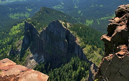 Table Mountain view
|
|
How to get there:
From Portland, OR
From Portland, travel east on Interstate Hwy 84 to Exit 44 to Cascade Locks.
Exit the freeway and cross over the Columbia River into Washington
via the Bridge of the Gods. Then turn left, or west, and head
about 3.2 miles to Hot Springs Road. Turn right and pass under
the railroad tracks, then turn right at the 1st intersection onto
Cascade Drive. Follow this road for about 2 miles around the east side
of Greenleaf Slough, and around past the former Bonneville Hotsprings Resort and
then west along the slough to a junction with an unnamed power line
service road. It is best to park
along the Greenleaf Slough so not to annoy residents and do your
homework to find your way to a 4WD road.
From Vancouver, WA
From I-205 exit for SR 14 in Vancouver, WA travel east on SR14 through
past Camas and Washougal and past Beacon Rock for about 32 miles and
you will come to Hot Springs Road on your left. Turn left and follow
this road under the railroad to the junction with Cascade Drive.
Turn right at the 1st intersection onto Cascade Drive.
Follow this road for about 2 miles around the east side
of Greenleaf Slough, and around past Bonneville Hotsprings Resort.
Since May of 2016, we need to no longer travel to the old trailhead
that used to be used for Table Mountain and Aldrich Butte as it
crosses over private land. Now there is no good way to access the
trail system near what use to be the Bonneville Hot Springs Resort.
Note: An alternate trailhead can be found by just walking
up the power line service road a quarter mile or so, as indicated
on the map, but parking is extremely limited. It is best to park
along the Greenleaf Slough so not to annoy residents and do your
homework to find your way to a 4WD road.
Note: This trail/road is used by motorbikes and ATVs.
|
|
|
A Virtual Hike of the Columbia River Gorge National Scenic Area


|
|


