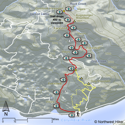
Length: 16 miles RT to summit including 1 mile RT to overlook
Elevation Change: 4400' gain
Season: Only recommend spring - too snowy or overgrown otherwise
Difficulty: Very Difficult
Permit: NW Forest Pass Required
GPS: N45 41.9562 W121 42.3252
Latitude: 45.69927
Longitude: -121.70542
Features:
This hike begins in the middle of the Dog Mtn trail head along Washington
highway 14. It is a long steady hike in and out of forested areas up the west
flank of Dog Mountain. This is a very difficult hike due to the elevation
gains and losses and regains, as well as the length.
At 2.8 miles you come to the junction with Dog Mtn, so
continue straight ahead and down hill. You loose about 400' elevation. In
about half mile you come to a power line service road which you will follow
for about a mile.
The trail then takes off into the deep woods and begins
to do some serious climbing. In another mile you will break out onto a ridge
that parallels the high-power lines. From this ridge you have many spectacular
views as you continue to climb.
There are some short switchbacks that take you
in and out of the forested areas as you climb the steeper part of this hike.
Finally you reach the heavily forested top of Augspurger. If you continue down
hill on a faint trail on the northwest side of the mountain, you will come
out onto an exposes slope with fantastic views and more than worth the hike.
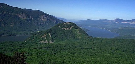 Looking west at Wind Mountain from the Augspurger Mountain trail
|
How to get there:
From Portland, travel east on Interstate Hwy 84 to Exit 44 to Cascade Locks.
Exit the freeway and cross over the Columbia River into Washington
via the Bridge of the Gods. Then turn right, or east, and head
east through Stevenson, Washington to the intersection of the Wind
River Highway to Carson, Washington. However, just continue east
on SR14 for another 6.2 miles and you will come to the large parking
area and trailheads for both the Dog Mountain and Augspurger Mountain hikes.
From Vancouver, WA travel east on SR14 through Stevenson, Washington to the
intersection of the Wind River Highway to Carson, Washington. However, just
continue east on SR14 for another 6.2 miles and you will come to the large parking
area and trailheads for both the Dog Mountain and Augspurger Mountain hikes.
From either direction, due to overcrowding at the Dog Mountain trailhead in peak season, we highly recommend for safety that
you consider using the Skamania County Gorge West End Transit bus .
The price is low and the convenience is high.
|