Length: 9 miles round trip
Elevation Change: 300 feet
Season: Late winter thru late fall
Difficulty: Moderate
Permit: NW Forest Pass Required
GPS: N45 42.2256, W121 29.2068
Latitude: 45.70376
Longitude: -121.48678
Features:
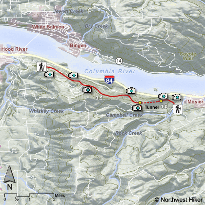
I call this the Moiser Tunnel hike, but most refer to it as the
Historic Columbia River State Trail. A project that was completed
in 2000 to restore a portion of the old Columbia River highway to
its original condition between Hood River and Mosier. Today, hikers
and bike riders enjoy this unique paved trail most anytime during
the year. Winter conditions can make the trail impassable.
One can start at either end of this 4.5 mile trail. I consider
beginning at the east end the better option in that you only need
to hike about .75 miles to come to the tunnel system for which
the entire hike is famous. I recommend hiking only half way
along this road, unless you have shuttle sytem in place to
pick you up at the other end. There is really no great reward
in hiking the entire 4.5 miles from one end to the other, only
to have to retrace the 4.5 miles back to your vehicle.
This hike is unique. It is certain worth doing. And the
reward is not only the very unique tunnel system, but the
incredible views of the Columbia River Gorge and in season
the wonderful foral displays. It is easy enough for the
very young and/or the elderly.
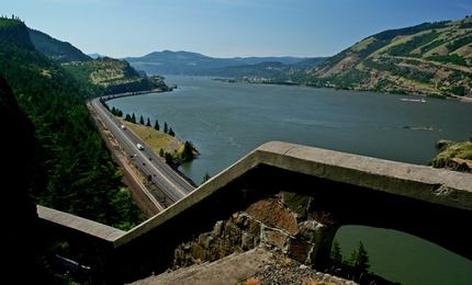 A view looking out from the Mosier Tunnel
|
|
How to get there:
Hatfield O. Hatfield East Trailhead: From I-84 take Exit #69/Mosier. Follow the Historic Columbia River
Highway as it curves left toward the town of Mosier. At the base of the bridge, turn left and circle under the bridge.
Drive approximately 1 mile to the trailhead parking lot on the left.
From the western end of the trail: Drive I-84 east to Exit 64 for Highway 35, White Salmon, and Government Camp.
After exiting, turn right at the Stop sign and then make another right turn.
Head up for 0.4 miles to a four-way intersection. Turn left here for the Historic Highway State Park.
Wind up the hill for 1.2 miles and turn left into the parking area at Mark O. Hatfield Western Trailhead.
|