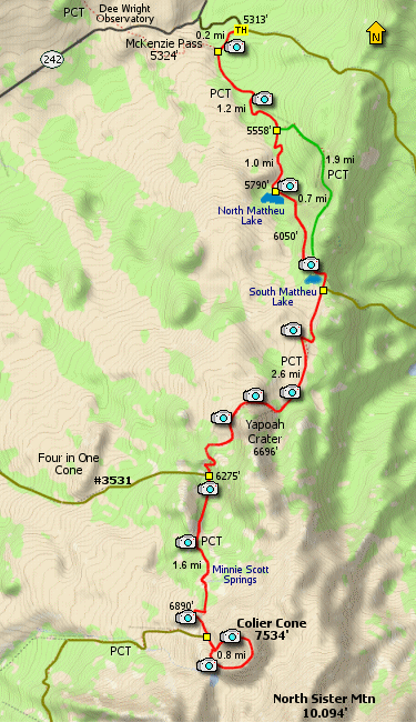
Length: 15.4 miles round trip
Elevation Change: 2600' elevation gain (cumulative)
Season: Summer thru Fall
Difficulty: Difficult
Permit: NW Forest Pass Required
Features:
This is one of the most outstanding day hikes
you could hope for along a stretch of the Pacific
Crest Trail in the Three Sisters Wilderness.
The hike could begin at McKenzie Pass, but I
chose to begin at a well marked trailhead located
just off highway 242. It is only a short walk west
and you come to the Pacific Crest Trail (PCT). Bear
left (south) and you are on your way.
Depending on the season in which you take the
hike, the floral displays can be magnificent.
The last two weeks in July are usually the
best time for flowers and minimal snow cover.
The trial climbs gently along the eastern edge
of a large lava flow. At about a mile and a half,
the PCT continues on to the left, but bear right
and follow this alternate trail to the Matthieu
Lakes.
Just before you reach the first lake, the trail
climbs steeply through a few switchbacks then
brings you down to North Matthieu Lake. This is
a fine lake and if weather permits, you might
enjoy a swim.
The trail follows along the eastern flank of
the lake and then climbs away as it heads for
the next lake. At about 0.7 miles you will
come to the PCT (again), and this time you want
to follow it.
Shortly you come to South Matthieu Lake. Now, this
is my favorite because of the extraordinary views
of the Cascade Mountains, especially North Sister.
The trail also skirts the lake on the east side,
then climbs to a junction to Trail #4068. Bear
right and continue on the PCT towards Yapoah Crater.
Now the trail must cross the large lava flow that
you have been skirting the entire hike thus far.
This is an interesting challenge, but done well,
and plenty of scenery to keep you busy. So, watch
you step, the lava is sharp.
The trail levels off for a bit just before working
its way around the north side of Yapoah Crater. The
trail does climb a bit along this part, and you get
excellent views to the north of Mt. Washington,
Mt. Jefferson, and Mt. Hood. Looming up in front
of you to the south are the North and Middle Sister.
After passing over the shoulder of Yapoah Crater,
the trail drops into a large meadow. In late July
this is usually overflowing with floral displays.
The trail will cross a creek at the south end of
the meadow then begins to climb.
Soon you come to Minnie Scott Springs. Here you
can refresh yourself and your water supply. To be
safe, use a filter. Now you are almost to your
goal.
The scenery really gets exciting at this point.
It seems like you are in a pre-historic/Jurassic
environment. You might expect a dinosaur to
come around the bend at any moment. But instead,
there in front of you is Collier Cone.
There appears to be a number of ways to climb
this cinder cone, but I chose what appeared to
be the expected route. Keep on the PCT over
Opie Dilldock Pass and as the trail descends
just a bit, you will see the Collier Cone
trail bearing off to the left (east).
Again, you can climb this cone clockwise,
or counter-clockwise. There is no special
best way. The trail takes you around the
top edge of Collier Cone, so you end up
where you began, either way.
I can't imagine anyone not loving this hike.
Although, if the wind is very strong, well,
that could dampen your appreciation.... ENJOY!
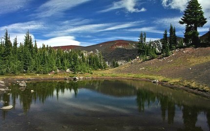
Small tarn just north of Collier Cone
|