

|
THE FOLLOWING MAP IS NOT TO BE USED FOR NAVIGATIONAL PURPOSES.
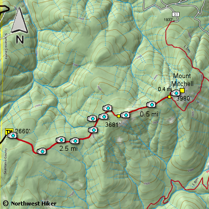
Map of the Mount Mitchell Hike
|
Length: 7.33 Miles round trip
Elevation Change: 2261' Elevation gain
Season: Spring thru Fall
Difficulty: Difficult
Permit: Discovery Pass
GPS: N46 01.373, W122 14.490
Latitude: 46.02288
Longitude: -122.24150
Features:
With the original trail to Mount
Mitchell no longer accessible, a
resourceful hike enthusiast managed
to revive an abandoned trail to the
rewarding summit of Mount Mitchell.
Because this is a non-maintained trail,
it is recommended for the more
experienced hikers as trail following
is sometimes sketchy. Also it is
recommended that this hike be done
with hiking poles due to the first
ultra steep section of the trail.
From the parking lot, the hike begins
up an abandoned 4WD road, but quickly
turns into a crude super steep scramble
up the hillside. Don't worry however,
the steep part does not last long
and then heads east into the forest.
The trail will alternate between lush
areas and drier pine areas. There are
some newer trail flags and old red blazes
along much of the trail.
The trail from here is in surprisingly
good condition until you come upon a
boulder field at the foot of towering basalt
wall, the bottom of Sugarloaf Mountain. This
too looks intimidating at first, but the trail
picks its way through the rocks along the wall’s
base. There are great views of Mount St. Helens
in this section on a clear day and some flowers
in season.
Shortly after leaving the rock wall the
trail joins up with the Sugarloaf Trail.
Hike east 0.5 miles to reach the junction
with the Mt. Mitchell trail, and then up the
final 0.4 miles to the summit.
When you break out onto the top of
this peak, you will be rewarded with
spectacular views and unique rock sculptures.
Needless to say, this hike is a
real gem.
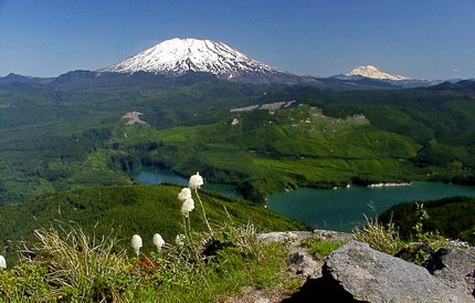
The summit of Mt Mitchell looms in front of Mt St Helens
NEW!
Click for PDF Topo Map of the drive
|
How to get there:
From Cougar, WA
Drive to Cougar, Washington and make a note of an odometer reading. Drive east for 3.9 miles on the Lewis River Road (503),
which becomes Forest Road 90, until it intersects Forest Road 10 (N46 03.320, W122 14.873).
Make an extreme right turn onto FR10 and follow it (S-6000) for about 0.8 miles and you will see a logging road turn off
to the right (N46 03.068, W122 14.873). Drive up this main road as it gains elevation. At the summit you will pass through
a logged area, then head straight down the other side (bearing left.) At about 6.25 miles look for an acute left turn
(N46 00.298, W122 15.623). Turn left and follow this one lane road about 1.9 miles until the road ends at a small parking area,
though no signs indicate that this is the trailhead. You begin the hike by walking uphill on an abandoned 4WD road which quickly
turns into a trail.
Note: Driving to this trailhead requires preparation. One should not rely on electronic resources as the route they may take you is not
correct or the most direct, and the road used may not be known to the database. It is best to print a detailed map of the final eight miles
of the drive before leaving home.
|
|
|
A Virtual Hike in the Gifford Pinchot National Forest


|
|


