Length: 3 Miles round trip
Elevation Change: 1164' Elevation gain / 400' loss
Season: Mid-Summer thru Fall
Difficulty: Challenging
Permit: NW Forest Pass Required
Features:
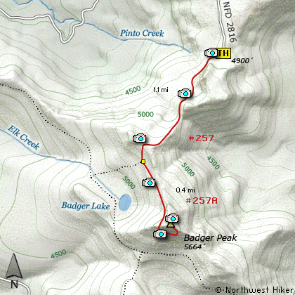
There are couple of ways to climb Badger Peak.
For this narrative I drove to the end of
Forest Road #2816. The trail immediately
descends a couple hundred feet in elevation
before it climbs steeply to the first ridge.
In season the wildflowers are abundant and
make this a delightful little hike. When
you reach the crest of Badger Ridge there
are great vistas especially if you walk
just a bit off trail to the west where
there is a rocky outcropping.
The trail now descends again a couple hundred
feet in elevation. At that point it meets
Trail #257A which takes you to the top of
Badger Peak. The trail is steep but well
maintained. Watch for snow as late as
mid-July.
The trail curves around the southwest face
of the peak and approaches from the southeast
side of the mountain. There used to be a
fire lookout on top and some of it is still
there.
The reason for taking this hike becomes
very clear as you gaze at all the surrounding
peaks; Mt Rainier to the north, Mt Adams to
the east, Mt Hood to the south, and of course
Mt St Helens to the southwest.
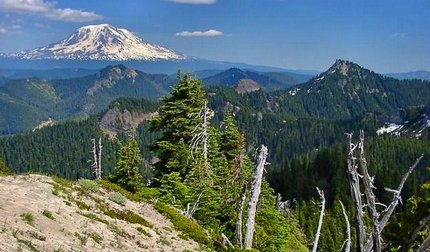
Mt Adams as seen from Badger Peak
|
How to get there:
NEW!
Click for PDF Directions Map of this Hike
From Randle, WA
If you are coming from the north via Randle, Washington, you will want to head south
out of town on State Route 131. Continue south on this road, which will become
Forest Road 25 for the remainder of the journey. In just short of 20 miles you will
come to the junction of Forest Road 99, which leads to hikes along Windy Ridge and
the east side of Spirit Lake.
But for this hike, just continue south on FR25 for about 2 more miles and turn left, or east, onto
Forest Road 28. Follow FR28 for about 2.7 miles and then bear right onto Forest Road 2816.
You will then follow FR2816 another 4.4 miles to the trailhead for this hike.
From Woodland, WA
From Woodland follow SR 503 and the Lewis River
Road for about 48 miles to the community of Cougar, WA. From Cougar, continue
east on the Lewis River Road which will turn into Forest Road 90 after you enter
the Gifford Pinchot National Forest. In about 18.5 miles you will come to the
junction of Forest Road 25. Continue straight ahead on FR25.
Follow FR25 north then for about 23 miles, and you will then come to Forest Road 28 on
your right. Follow FR28 for about 2.7 miles and then bear right onto Forest Road 2816.
You will then follow FR2816 another 4.4 miles to the trailhead for this hike.
From Carson, WA
If however, you plan to approach this hike from the Columbia River Gorge area, then
begin at Carson, Washington and head northwest on the Wind River Hwy. In 7.5 miles
you will pass through the little community of Stabler, and in another 5.8 miles you
will come to the junction of Forest Road 30. Turn right onto FR30 and follow this
road for 13.2 miles north along the Wind River and then up a steep incline and onto
a plateau where you will come to the junction of the Curly Creek Road. Turn left
onto the Curly Creek Road and follow it downhill past an excellent view area for
about 5.1 miles until you come to Forest Road 90. Turn left onto FR90 and follow
it west for another 4.1 miles until you come to the junction of FR90 and FR25.
Turn right onto FR25.
Follow FR25 north then for about 23 miles, and you will then come to Forest Road 28 on
your right. Follow FR28 for about 2.7 miles and then bear right onto Forest Road 2816.
You will then follow FR2816 another 4.4 miles to the trailhead for this hike.
|