Length: 10.2 Miles round trip
Elevation Change: 1800' Elevation gain/loss
Season: Summer thru Fall
Difficulty: Challenging
Permit: NW Forest Pass Required
Features:
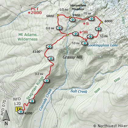
This delightful hike up Stagman Ridge brings a large variety
of floral displays in season, and a large variety of vistas.
The trail begins at a parking area developed at the end of
an old logging road. The trail follows the old road for
about a quarter mile before entering the Mt Adams
Wilderness Area.
This hike never gets very steep if you take it clock-wise.
You will hike over one ridge, drop a bit to a small valley,
then climb back toward Mt Adams. At about 2.5 miles you
break out into an open meadow with a spectacular view
of the mountain. A short distance later, you will
come to an intersection of the trail that takes you
to the PCT. You will return to this intersection when
you complete the loop after visiting Looking Glass Lake.
The trail climbs for the next mile until it meets
the PCT #2000. At that point you follow the PCT
toward Mt Adams until it intersects Trail #9. Trail #9
was originally created to be the Around the Mountain Trail
for Mt Adams, but since the boundaries have changed,
and because of Mother Nature, it is difficult to try
to encircle the mountain.
Anyway, at this point bear to the right and follow
Trail #9 south and east until you come to the
intersection of Trail #9-A. Follow Trail #9A
downhill to Looking Glass Lake. The trail
crosses a couple of streams that can be a
challenge during heavy run-off.
Just before you reach Looking Glass Lake,
you will pass an intersection of the trail
that will take you back to Trail #12 on
Stagman Ridge. You will need to return
to this point after visiting the lake.
Looking Glass Lake is a beautiful little
lake nestled against the southwest side
of Mt Adams. Trees surround most of the
lake, but Mt Adams is visible from the
southwest side of the lake. When you
are ready, climb back to the intersection
that you passed earlier on the way to the
lake.
Upon reaching that intersection, bear left
and follow the trail across a couple of
streams back to Trail #12, which you will
follow back to the trail head where you
began.

Mt Adams as seen from the Stagman Ridge
|
How to get there:
NEW!
Click for PDF Directions Map of this Hike
From Portland, OR
From Portland, travel east on Interstate Hwy 84 to Exit 64 at Hood River.
Turn left, and pass under the freeway and cross the toll bridge ($2.00)
into Washington state. Turn left onto SR14 and drive approximately 1.5
miles to state road 141 Alt. Turn right onto SR141 Alt. and follow it another
2 miles and merge bearing left onto SR141. Then travel north on SR141
for another 19 miles to Trout Lake and the junction to Mt. Adams Road. Bear
right and forward onto Mt. Adams Road for about 1.3 miles and you
come to the junction with Forest Road 23. Bear left and forward
onto FR23 and continue north for about 7.7 miles and you will
come to the junction of Forest Road 070. Bear right onto FR070
and follow this unpaved road downhill and across a bridge and back
uphill for about 3.5 miles and you will come to the junction of
Forest Road 120. Make a sharp right uphill turn onto FR120 and
continue through a series of curves for about another mile and
you will come to the trailhead for this hike.
|