Length: 4 miles total for all 3 locations
Elevation Change: 100' Elevation change
Season: Year Round
Difficulty: Easy
Permit: NW Forest Pass Required
GPS: N46 6.132, W121 54.39
Latitude: 46.1022
Longitude: -121.9065
Features:
For the purposes of this CD, I do not cover
the length of Trail #31 which follows several
miles along the Lewis River. My goal is to
show you the beauty of the 3 major falls on
the Lewis River and inspire you to visit
these falls and if you have time, hike as
much of the river trail as you can.
Also, for the purpose of this CD all the
photos I share were taken from legitimate
trail locations, not from leaving the
trail to climb down steep banks and walk
out into the river for those very special
shots.
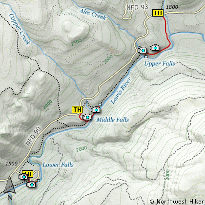
As you drive up Forest Road #90, you will
come sequentially to the Lower, Middle, and
Upper Lewis River Falls. At the lower falls
parking area, it is just a short walk to
viewing areas where you can get breath
taking vistas of the Lower Lewis River
Falls. One of the paths leads right out
onto the river bed above the falls, and
its steps are carved into the bed rock.
The Middle Lewis River Falls trail is a
bit longer than the lower. From the
parking area, the trail descends gently
to the river and flows it north to a
viewing area below the middle falls.
The Upper Lewis River Falls trail begins
along Forest Road #90 just before the
Quartz Creek bridge. The trail gently
follows the Lewis River downstream for
about a mile where it then drops down
next to the upper falls. To get better
views of the upper falls, one needs to
follow Trail #31 further downstream and
look back.
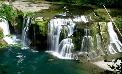
Lower Lewis River Falls
|
How to get there:
NEW!
Click for PDF Directions Map of this Hike
From Woodland, WA
From Woodland follow SR 503 and the Lewis River
Road for about 48 miles to the community of Cougar, WA. From Cougar, continue
east on the Lewis River Road which will turn into Forest Road 90 after you enter
the Gifford Pinchot National Forest. In about 18.5 miles you will come to the
junction of Forest Road 25. Turn right and remain on FR90 for another 4.1 miles
and you will pass the junction to the Curly Creek Road. Continue on FR90 for
another 9.9 miles and you will come to the main campground for the Lower Lewis River
Falls. Turn into the campground area and follow signs to the parking area
for hikers. To view the two other major falls on the Lewis River in this area,
just continue east on FR90 and watch for the signs that direct you to the parking
and trails for each.
From Carson, WA
If however, you plan to approach this hike from the Columbia River Gorge area, then
begin at Carson, Washington and head northwest on the Wind River Hwy. In 7.5 miles
you will pass through the little community of Stabler, and in another 5.8 miles you
will come to the junction of Forest Road 30. Turn right onto FR30 and follow this
road for 13.2 miles north along the Wind River and then up a steep incline and onto
a plateau where you will come to the junction of the Curly Creek Road. Turn left
onto the Curly Creek Road and follow it downhill past an excellent view area for
about 5.1 miles until you come to Forest Road 90. Turn right onto FR90 and follow
this road for about 10 miles and you will come to a campground at the Lower Lewis
River Falls area. Turn into the camp area and follow the signs to trail parking.
|