Length: 14.6 Miles round trip
Elevation Change: 2000' Cumulative Elevation gain
Season: Summer thru Fall
Difficulty: Difficult because of length
Permit: NW Forest Pass Required
Volcano Alert
Call this number to see if this trail is closed:
360-449-7800
Features:
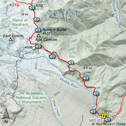
This hike follows Trail #234 from the Ape Canyon trailhead for the first
5.5 miles to the junction with the Loowit Trail #216, which goes completely
around Mt. St. Helens. This hike follows the Loowit Trail north for 1.8
miles to the junction with Trail 216D.
The hike begins a modest climb along the edge of a mudflow from the
1980 eruption of Mt. St. Helens. Compare the devastation of the mud
flow area with the area where the trail is located, and you get some
sense of how cataclysmic the eruption event was to the non-blast side
of the mountain.
The hike takes you through a young immerging forest for a little over
a mile, then you are treated to one of the few remaining old-growth
forests which flank the mountain. Most did not survive the eruption
of 1980. At this point the trail begins to climb more steeply, and
you will encounter a number of switchbacks.
As the trail proceeds to the head of Ape Canyon you will experience a
bit of up and down hiking. With each ridge you climb, you are higher
than the one before, even though you may drop some elevation in between.
Also, with each ridge you climb, you get better and better views.
At about 5.5 miles you will come to the head of Ape Canyon. Be cautious
as the sides of the trail are very steep. Here you meet up with the
Loowit Trail #216. Proceed to your right and follow this trail uphill
towards the Plains of Abraham.
In about a half mile you will enter the plains and if your are there
at the right season, you will encounter a fantastic floral display.
And if you are there during good weather, you will be treated to
outstanding views of Mt Adams to the east, and Mt St Helens itself
towering above you.
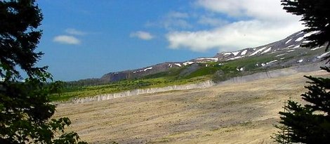
Muddy River lahar field
|
How to get there:
NEW!
Click for PDF Directions Map of this Hike
From Woodland, WA
From the junction with I-5 follow SR503 east from Woodland, WA approximately 23
miles to the junction of the Lewis River Road with SR503. Continue east on the
Lewis River Road another 4.4 miles to the junction of Forest Road 81 just before
you get to Cougar. Continue east through Cougar on the Lewis River Road, which
becomes Forest Road 90, for about 7.4 miles to the junction of Forest Roads 90 and 83.
Turn left on FR83. In about 1.7 miles you will pass the road that leads to the Ape Caves, but continue north on FR83.
In another 1.3 miles you will pass the junction to Forest Road 81, but bear right and continue on
FR83. In about 3.8 miles you will pass the parking area for the June Lake hike, but continue on
another 4.2 miles to the parking area for the Ape Canyon hike. The parking area for Lava Canyon
is just a bit further, so don't confuse them.
|