|
THE FOLLOWING MAP IS NOT TO BE USED FOR NAVIGATIONAL PURPOSES.
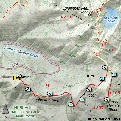
Map of the Harry's Ridge, Spirit Lake Hike
|
Length: 7.8 Miles round trip
Elevation Change: 800' Cumulative Elevation gain
Season: Summer thru Fall
Difficulty: Moderate
Permit: Wrist-Band from Observatory
GPS: N46 16.602,W122 13.008
Latitude: 46.2767
Longitude: -122.2168
Volcano Alert
Call this number to see if this trail is closed:
360-449-7800
Features:
This hike begins at the same location as
the Coldwater Peak hike... at the northeast
corner of the Johnston Ridge Visitor Center
parking lot. The first 1/4 mile is paved,
then becomes well traveled natural surface.
The first 2 miles of this hike are heavily
hiked by visitors to the Johnston Ridge
Visitors Center. These first 2 miles offer
incredible views of Mt St Helens to the
south and Harry's Ridge to the east, and
Coldwater Peak to the north.
At 2.3 miles you will come to the junction
of Trail #207 which leads over to Windy
Ridge. Keep straight ahead on your Trail #1,
which is also called the Boundary Trail.
This is the lowest point of the hike, and
you will now climb gently toward the junction
to the trail that leads to the top of Harry's
Ridge.
Just before you each the junction to Trail #208,
you will cross a substantial iron bridge. Views
along this portion of the trail are mostly of
Mt St Helens, Coldwater Peak, and Harry's Ridge.
When you reach Trail #208, bear right onto the
trail which climbs steeply up Harry's Ridge.
Soon you will be treated to incredible views
of Spirit Lake and Mt Adams to the east. As
you climb Harry's Ridge the views get better
and offer the best possible frontal view of
the blast zone of Mt St Helens. This ridge
was the bulls eye during the cataclysmic event
of May 1980. The blast not only removed the
timber on this ridge, but it even removed
the soil. What is there now is the ash and
pumice left over from the explosion.
At the top you will find an old propane tank
that was once used to fuel the equipment that
was monitoring the mountains behavior. You
can see the visitors center on Johnston Ridge
from here too.
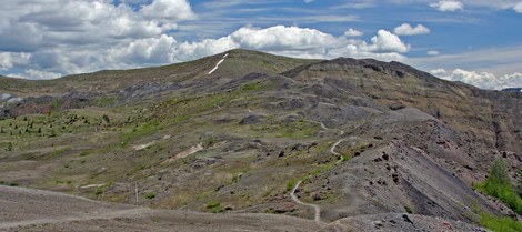
Harry's Ridge as seen from the Boundary Trail on Johnston Ridge
|
How to get there:
NEW!
Click for PDF Directions Map of this Hike
From Seattle, WA
Drive south on I-5 to the junction of State Road 504. Exit the freeway, and turn
left (east) onto SR504 and follow it east. At five miles you will pass the Silver Lake
Visitor Center and in another 38 miles you will come to the junction to SR504 E.
Bear right onto SR504 East and follow it another 8 miles to the Johnston Ridge Observatory.
(closed in winter)
From Portland, OR
Drive north on I-5 to the junction of Washington State Road 504. Exit the freeway, and turn
right (east) onto SR504 and follow it east. At five miles you will pass the Silver Lake
Visitor Center and in another 38 miles you will come to the junction to SR504 E.
Bear right onto SR504 East and follow it another 8 miles to the Johnston Ridge Observatory.
(closed in winter)
|
|
|
A Virtual Hike of the Mt. St. Helens National Volcanic Monument


|
|