

|
THE FOLLOWING MAP IS NOT TO BE USED FOR NAVIGATIONAL PURPOSES.
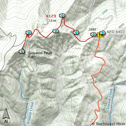
Map of the Siouxon Peak Hike
|
Length: 2.6 Miles round trip
Elevation Change: 1289' Elevation gain
Season: Summer thru Fall
Difficulty: Difficult
Permit: No Pass Requirement
Features:
Siouxon Peak is a steep but rewarding
hike. A hiker can reach this summit
via several routes, but this CD will
examine only 2. The easiest option
is to drive to the end of Forest Road
6403 where you are faced with a mere
1.3 mile hike to the top. The other
option on this CD is to come from
the Siouxon Creek valley.
Climbing Siouxon (pronounced Sue-sawn)
is a difficult task regardless of
which trail head you select. If you
begin your hike at the Siouxon Creek
trail head, you have first to hike up
Siouxon Creek for about 4 miles before
you begin the arduous task of climbing
out of the valley to the upper trail
head, then climbing to the top.
In order to reach Siouxon Peak from
the creek, you are faced with wading
across Chinook Creek, which at best
is knee deep and about 50 feet across.
Chinook Creek Falls is beside you,
creating a beautiful scene to enjoy
while you negotiate the creek. It
would be wise to carry some wading
shoes with you on this hike.
As soon as you cross the creek, the
trail gets very steep and remains that
way for about a mile. Eventually the
trail follows an old logging road and
is far more level. At about 3 miles
you will come to the other optional
trail head.
At this point you begin to hike the
last 1.3 miles and climb nearly 1300'.
The trail continues to follow an old
logging road that was used to access
the fire lookout tower that used to
be on top of Siouxon Peak. It is
this last part of the hike that you
get really outstanding views of the
surrounding valleys and mountains.
Mt Adams to the east, Mr Rainier to
the north, and Mt St Helens to the
northwest are viewed along this part
of the hike. At about a mile from
the 2nd trail head, the trail leaves
the old road bed and climbs steeply
to the north side of the peak, then
follows around to the west side where
it finally climbs to the top.
Trees on the northwest side of the
peak prevent you from seeing Mt St
Helens from the top, but views to
the north, east, and south are
outstanding.
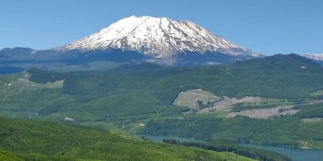
Mt St Helens as seen from the Siouxon Peak trail
|
How to get there:
NEW!
Click for PDF Directions Map of this Hike
From Portland, OR
From Portland, travel east on Interstate Hwy 84 to Exit 44 to Cascade Locks.
Exit the freeway and cross over the Columbia River into Washington
via the Bridge of the Gods. Then turn right, or east, and head
east through Stevenson, Washington to the intersection of the Wind
River Highway to Carson, Washington. Bear left onto the Wind River
Highway which will take you through Carson, Washington.
from Vancouver, WA
From Vancouver, WA travel east on SR14 through Stevenson, Washington to the
intersection of the Wind River Highway to Carson, Washington. Bear left onto the
Wind River Highway which will take you through Carson, Washington.
from Carson, WA
Continue north on the Wind River Highway (FR30) for about 8.6 miles to the
little community of Stabler and the junction with Forest Road 43, also called
Hemlock Road. Continue northwest on FR30 for another 5.4 miles and you will
pass a fish hatchery on the left. Continue on another half mile and you
will come to the junction with Forest Road 3065, which continues straight ahead.
Bear right and continue on SR30 for another 2.1 miles
to the junction with Forest Road 64. Bear left onto FR64 and climb steeply
for another 6 miles to the junction with Forest Road 58. Bear right at this
junction and stay on FR64. This part of the road is becoming almost impassable.
The trees and bushes are growing in on both sides, so don't take a vehicle that
you don't want scratched. It is about 7 miles from this junction with FR56 to
the parking area and trailhead for this hike. Somewhere along this difficult
part of the drive, you will turn onto Forest Road 6403. Follow it to the end.
|
|
|
A Virtual Hike in the Gifford Pinchot National Forest


|
|


