Length: 5.2 Miles round trip
Elevation Change: 1400' Elevation gain
Season: Late Spring thru Fall
Difficulty: Challenging
Permit: NW Forest Pass Required
Features:
This northern approach to Silver Star
Mountain via a trail called Ed's Trail,
is one of the most beautiful hikes in
the Gifford Pinchot National Forest.
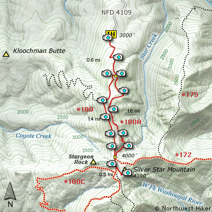
The trail head is at the end of Forest
Road #4109.
The hikes up Silver Star Mountain almost
all follow old road beds that were in
place for logging and for access to the
fire lookout facility that used to be
on the top of the mountain. This hike
is a partial exception to that rule.
The begins a moderate climb and after
a couple switchbacks follows one of
the old roads for a short distance.
Then the trail leads away from the
road bed and becomes a stand alone
trail referred to as Ed's Trail.
Ed's Trail is a delightful hike up
the east side of the Silver Star Mtn
ridge line. In June this hike is
a floral garden. Anytime the
weather cooperates you have
exceptional views of the Cascade
Volcanos, such as Mt St Helens,
Mt Rainier, Mt Adams, Mt Hood,
and even Mt Jefferson.
This trail runs parallel to the
road bed trail that you can use
on return for variety. At times
the trails are only a few hundred
feet apart. Ed's Trail takes you
along the east side of the ridge
and through a free standing arch.
Right after the arch, the trail
becomes very steep and challenging.
However, it never seemed dangerous
to me.
At about 2 miles this trail connects
with the road bed trail that will take
you to the summit of the mountain.
As you approach the top you will notice
that Silver Star appears to have 2
summits. The one on the north is
obviously the higher. Both summits
are worth the time and effort.
After feasting on the vistas and
floral displays, you can return on
the alternate route via the road be
trail that takes you back to the
original trail where you began the hike.
Eds trail up Silver Star Mountain
|
How to get there:
NEW!
Click for PDF Directions Map of this Hike
From Battle Ground, WA
Travel north from Battle Ground, WA on SR503 for approximately 5.6 miles to the
Lucia Falls Road. Turn right and follow this road for about 14 miles east to the
Sunset Falls Road. Turn right and travel east on the Sunset Falls Road for 2 miles, where
it intersects the Dole Valley Road. Turn right onto the Dole Valley Road, and
cross the East Fork of the Lewis River and head south for 2.4 miles. Turn left
onto Forest Road 1100 and follow it for about 6.6 miles until it intersects
Forest Road 4109. Turn right onto FR 4109 and follow it for about 1.8 miles
to the trailhead for various hikes up Silver Star Mountain.
|