

|
THE FOLLOWING MAP IS NOT TO BE USED FOR NAVIGATIONAL PURPOSES.
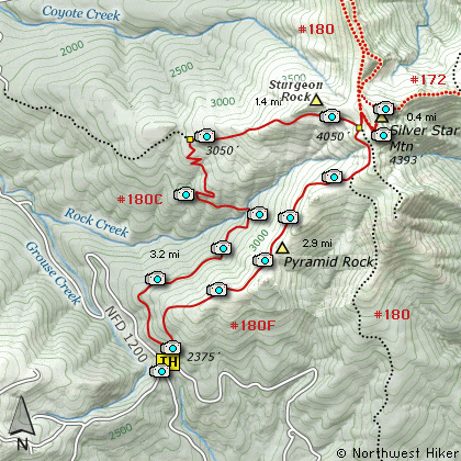
Map of the Silver Star Mountain Hike
|
Length: 8.3 Miles round trip
Elevation Change: 2015' Elevation gain
Season: Late Spring thru Fall
Difficulty: Challenging
Permit: Discovery Pass Required
GPS: N45 43.344, W122 16.164
Latitude: 45.7224
Longitude: -122.2694
Features:
This is probably the most common approach
to hiking Silver Star Mountain. The trail
begins along Forest Road #1200 at the
saddle between Larch Mountain and Silver
Star. The trail begins to climb fairly
steep at first. In about a quarter mile
you will come to a junction. For this
hike description, I took the left option.
The trail is not steep at this point and
goes through rather dense new-growth
forest and shrubs. In about a half mile
you begin to break out into open areas
with fantastic views of Silver Star Mtn,
Pyramid Butte, and Sturgeon Rock.
At about 2 miles you will cross a small
stream on a small bridge. There is a
falls a short distance downstream from
the bridge, but no trail access. The
trail begins to climb quite steeply
at this point.
At a little over 3 miles you will come
to an old road which the trail now
follows all the way to the top of
Silver Star Mtn. As you hike up
this part of the trail you will have
views of Pyramid Butte just south of
you and of Larch Mtn to the southwest.
Silver Star Mountain is covered with
old roads that were once used as access
to the fire lookout on top of the mountain.
In about another mile and a half you will
come to a junction of some of these roads.
Bear a sharp left for a short distance,
then at the next junction, bear a sharp
right and follow this old road to the
saddle between the two summits of the
mountain. The northern summit is the
higher.
Upon return, retrace your steps through
the first 2 junctions then follow the
road straight ahead to Trail #180F.
Follow this trail/old road bed back
down the mountain. The trail will take
you right beneath Pyramid Butte. In
season this entire hike is a walk through
a fantastic floral garden.
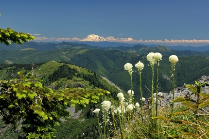
Mt. Adams as seen from the summit of Silver Star Mountain
|
How to get there:
NEW!
Click for PDF Directions Map of this Hike
From Battle Ground, WA
Travel north from Battle Ground, WA on SR503 for approximately 5.6 miles to the
Lucia Falls Road. Turn right and follow this road for about 14 miles east to the
Sunset Falls Road. Turn right and travel east on the Sunset Falls Road for 2 miles, where
it intersects the Dole Valley Road. Turn right onto the Dole Valley Road, and
cross the East Fork of the Lewis River and head south for about 5.4 miles.
Continue straight ahead on Forest Road 1200 for another 4.9 miles and you will
come to a saddle that is situated between Silver Star Mtn to the east and Larch
Mountain to the west. Here you will see the trailhead for this hike.
|
|
|
A Virtual Hike in the Gifford Pinchot National Forest


|
|


