Length: 12.4 Miles round trip
Elevation Change: 1400' Elevation gain
Season: Year Round
Difficulty: Challenging
Permit: No Pass Requirement
GPS: N45 34.638 W121 47.574
Latitude: 45.6587753
Longitude: -121.9428488
Features:
NEW!
Click for PDF Topo Map of this Hike
This is a revised presentation for
the hike up Aldrich Butte in the
Columbia River Gorge.
Over the years it has become more
and more difficult to reach the
traditional trailheads for this hike,
so now we explain how to hike this
worthy butte via the only legitimate
access.
This new route nearly triples the length
of the hike and adds considerable elevation
gain/loss in the process. However, this
new approach offers many additional vistas
and features that make this new long approach
truly worth the effort.
Here is a little jewel of a hike
located just inside of the Gifford
Pinchot National Forest in the Columbia
River Gorge National Scenic Area.
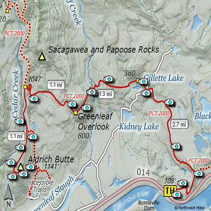
This hike now begins at the Bonneville
Trailhead which is located just across
Hwy 14 from Bonneville Dam. You will
follow the trail a short distance and
will then encounter the Pacific Crest
Trail. You will follow the PCT for
about 5 miles.
This part of the hike is the same
as the hike description to Gillette
Lake and Greenleaf Overlook, in that
you will pass Gillette Lake and the
Overlook along the way.
A little over a mile from Greenleaf
Overlook, you will come to a place
where the PCT begins to follow an
old logging road. It is at this point
that you will need to make a sharp
right turn and head away from the PCT,
following the old logging road toward
Aldrich Butte.
Just before you
reach the top you will be able to
enjoy vistas of the Columbia River
Gorge, including Bonneville Dam.
From the top of Aldrich Butte you
have an outstanding view of Table
Mountain to the north, the Columbia
River with Augspurger Mountain to
the east, and the Benson Plateau
and Tanner Ridge to the south
in Oregon.
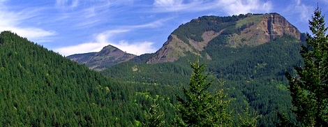
Table Mountain as seen from the summit of Aldrich Butte
|
How to get there:
NEW!
Click for PDF Directions Map of this Hike
How to get there:
Bonneville Trailhead:
From Oregon, take I-84 to Exit #44/Cascade Locks. Follow the signs
to Bridge of the Gods/Stevenson and cross the bridge ($2 toll). Take a left and travel east
on WA Hwy 14 for about a mile and a half. After you see Bonneville Dam on your left, start
looking for the trailhead sign on your right.
From Vancouver, travel east on WA Hwy 14 for 35 miles. After you pass Beacon Rock State Park
and the town of North Bonneville, you'll see Bonneville Dam on your right. Just past the
dam on the left side of the highway is the Bonneville Trailhead.
|