Length: 17.2 Miles round trip
Elevation Change: 3420' Cumulative Elevation gain
Season: Late Spring thru Fall
Difficulty: Very Difficult
Permit: NW Forest Pass Required
Features:
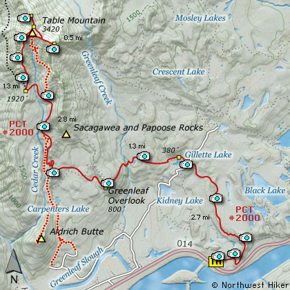
This hike begins at the Bonneville Dam
Trail Head just across Hwy 14 from
the north end of Bonneville Dam on
the Columbia River. A person can
climb Table Mountain by beginning the
hike at the same location as the
Aldrich Butte hike. But for this CD
I am taking the traditional route.
The trail leaves the parking area on
the east side a climbs a bit as it
makes its way to the main trail, the
Pacific Crest Trail #2000(PCT). It is
about a half mile from the trail head.
Upon reaching the PCT, bear left and
follow the trail through recently logged
areas and across a power line access
road to Gillette Lake. The trail
continues past the lake on the north
side and crosses a small stream then
begins a gentle climb toward Greenfield
Overlook. You will come to a small
pond as you hike through rather dense
forest.
Just before you come to Greenleaf Creek
you will break out into the open. Here
you will have a great view of Table Mountain.
If you look closely, you will see a rather
large waterfall on Greenleaf Creek up on
the lower east side of Table Mtn. After
this clearing, the trail descends to a
very substantial bridge over Greenleaf
Creek.
After crossing Greenleaf Creek, the trail
climbs sharply for a bit as it works its
way to the Greenleaf Overlook. Here you
will experience excellent views of the
Columbia River Gorge looking east, south,
and west. The trail continues to climb
on its way to Table Mtn.
You will walk along and occassionally cross
an old logging road as the trail passes
through a wet swampy area. After which the
trail begins its most serious climbing.
At about 5 miles the trail joins with an
old road and follows the road for a bit
as it continues to climb. This old road
can be taken from the Aldrich Butte trail
head to climb Table Mtn.
You will note that the PCT doesn't really
follow this old road bed, but rather follows
along side it. I'm not sure why. Never
the less in another mile you will come to
a significant saddle. The PCT will go on
straight ahead and begin to drop. Do NOT
follow the PCT past this saddle. Instead
you will notice a users trail on the north
side of the PCT. Take this small trail
and it will lead you to the top of Table
Mountain.
As you begin the final climb of the mountain
the trail becomes very very steep. There are
times that you may find yourself using your
hands to climb up the steep rocky trail. However,
it never seems difficult to follow the trail.
As you gain elevation you will be treated to
increasingly better views of the surrounding
terrain.
Finally, the trail breaks out on top of Table
Mountain. The top of the mountain is shaped a
bit like the letter Y. Just follow the trail
to the far north side of the mountain for
outstanding views of Mt St Helens, Mt Rainier,
and Mt Adams. Then follow the Y part of the
trail to the southeast side of the mountain
where you will come to an incredible steep
and high cliff. USE EXTREME CAUTION while
in this area. The trail gets very close
to the edge of this cliff.
After enjoying the rewards of your climb,
you have 2 options for getting off the
top of this mountain. I have descended
both ways, and I would recommend returning
the same way you came up. However, there
is a clearly visible trail right down the
face of the mountain which eventually ends
up back on the PCT which you followed to
get there.
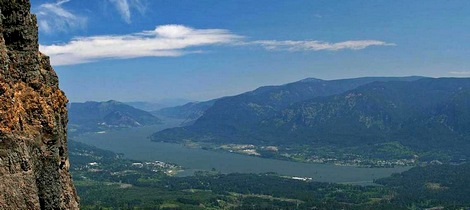
The cliff face of Table Mountain
|
How to get there:
NEW!
Click for PDF Directions Map of this Hike
From Portland, OR
From Portland, travel east on Interstate Hwy 84 to Exit 44 to Cascade Locks.
Exit the freeway and cross over the Columbia River into Washington
via the Bridge of the Gods. Then turn left, or west, and head
about 2 miles to the Bonneville Trailhead on your right. Park
here and begin your hike via a cutoff trail to the PCT.
From Vancouver, WA
From I-205 exit for SR 14 in Vancouver, WA travel east on SR14 through
past Camas and Washougal and past Beacon Rock for about 33 miles and
you will come to the Bonneville Trailhead on your left. Park here
and begin your hike via a cutoff trail to the PCT.
|