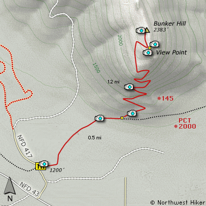
Length: 3.4 Miles round trip
Elevation Change: 1200' Elevation gain
Season: Spring thru Fall
Difficulty: Challenging
Permit: NW Forest Pass Required
Features:
This short little hike is just a stones
throw from the Whistle Punk hike. It is
located on Forest Road 417 just a short
distance of FR 43. The trail head is
located where the Pacific Crest Trail
(PCT 2000) crosses FR 417.
The trail begins on a level walk across
a field toward Bunker Hill. After
crossing the field the trail enters a
dense growth area for about a half mile.
Then you will come to a junction where
the PCT continues on its way north, and
the trail to the top of Bunker Hill bears
off to the left. Follow this Trail #145.
There are a couple of good reasons to
climb to the top of the tree covered Bunker Hill. One
reason is that you get to walk through a
small stand of Old Growth trees. The
trail is fairly steep and has a number
of switchbacks.
The 2nd reason to climb the hill is that
just before you get to the top, at the
corner of the last switchback there is a
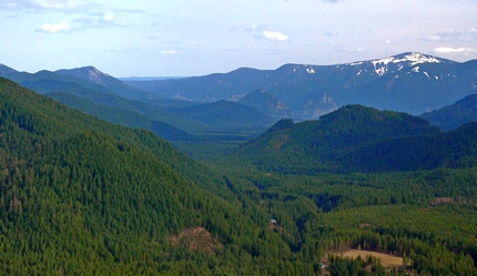
small users trail out to a great viewpoint.
Go ahead and take a quick look at the top
of this tree covered hill, then return
to the users trail and walk out to the
viewpoint. This makes the hike really
worth it.
Old growth trees on Bunk Hill
|
How to get there:
NEW!
Click for PDF Directions Map of this Hike
From Portland, OR
From Portland, travel east on Interstate Hwy 84 to Exit 44 to Cascade Locks.
Exit the freeway and cross over the Columbia River into Washington
via the Bridge of the Gods. Then turn right, or east, and head
east through Stevenson, Washington to the intersection of the Wind
River Highway to Carson, Washington. Bear left onto the Wind River
Highway which will take you through Carson, Washington.
from Vancouver, WA
From Vancouver, WA travel east on SR14 through Stevenson, Washington to the
intersection of the Wind River Highway to Carson, Washington. Bear left onto the
Wind River Highway which will take you through Carson, Washington.
from Carson, WA
Continue north on the Wind River Highway (FR30) for about 8.6 miles to the
little community of Stabler and the junction with Forest Road 43, also called
Hemlock Road. Turn left onto FR43 and cross a bridge over the Wind River and
continue west for a couple of miles to the junction of FR43 and Forest Road 417.
Turn right onto FR417 and follow it but a short distance, and you will see the sign for the
Pacific Crest Trail on your right. Park here for the trailhead for
this hike.
|