Length: 7.8 Miles round trip
Elevation Change: 2680' Elevation gain
Season: Summer thru Fall
Difficulty: Difficult
Permit: NW Forest Pass Required
Features:
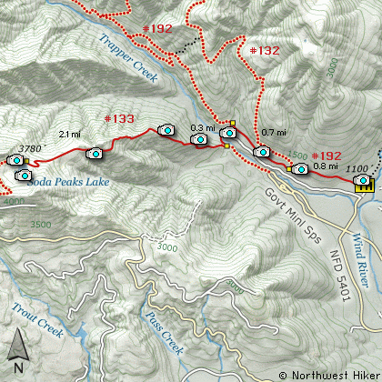
This approach to Soda Peaks Lake begins
off Forest Road #5401 which is a short
distance from the Wind River Hwy #30.
Also, this approach to Soda Peaks Lake
is for those who are desperate for a
heart attack... in other words this is
a very challenging hike!
See Hike #58 for a more reasonable
way to get to Soda Peaks Lake.
Having said that, lets hike. The
trail begins fairly level as it leaves
the trail head. The trail parallels
a private road that follows Trapper
Creek for about 1.5 miles. At .8
miles you will come to the junction of
Trail #132. Keep straight ahead and
continue on until you reach the junction
of Trail #133. Bear left and follow
this trail.
Trail #133 descends a bit to Trapper
Creek and crosses on a vehicle bridge
that has been transformed into a hikers
bridge. After crossing the creek, the
trail veers off to the left as it prepares
to climb like a homesick angel up a very
steep mountain. Just before lift off,
you will pass a junction of a trail that
leads back to the Government Mineral
Springs.
Now the climb begins. Thank goodness for
the switchbacks. This trail climbs and
climbs and climbs. Then it climbs some
more. Then after that... you guessed it,
it climbs even more. A couple enjoyable
aspects to this approach to Soda Peaks
Lake is that you get to hike/climb through
a significant Old Growth Forest. I mean,
these trees are really big and really old.
Then there are also occasional views as
you make your way up this mostly heavily
timbered trail.
When you finally do get to Soda Peaks Lake,
if you have any energy left, walk down to
the lake, then follow the user trail to the
east side of the lake and up the rocky part
of the East Soda Peak. Here you get some
frosting for your hiking cake as your
view out at Mt St Helens, Mt Rainier,
and Mt Adams.
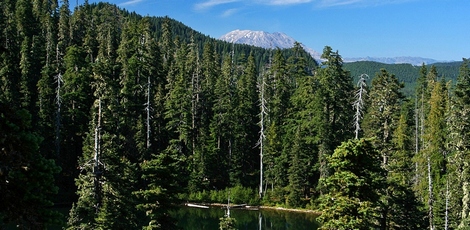
Mt St Helens peeking over ridge above Soda Peaks Lake
|
How to get there:
NEW!
Click for PDF Directions Map of this Hike
From Portland, OR
From Portland, travel east on Interstate Hwy 84 to Exit 44 to Cascade Locks.
Exit the freeway and cross over the Columbia River into Washington
via the Bridge of the Gods. Then turn right, or east, and head
east through Stevenson, Washington to the intersection of the Wind
River Highway to Carson, Washington. Bear left onto the Wind River
Highway which will take you through Carson, Washington.
from Vancouver, WA
From Vancouver, WA travel east on SR14 through Stevenson, Washington to the
intersection of the Wind River Highway to Carson, Washington. Bear left onto the
Wind River Highway which will take you through Carson, Washington.
from Carson, WA
Continue north on the Wind River Highway (FR30) for about 8.6 miles to the
little community of Stabler and the junction with Forest Road 43, also called
Hemlock Road. Continue northwest on FR30 for another 5.4 miles and you will
pass a fish hatchery on the left. Continue on another half mile and you
will come to the junction with Forest Road 3065, which continues straight ahead.
The Wind River Highway, or FR30, makes a sharp right turn here and heads north. You,
however, do not turn, but continue straight ahead on Forest Road 3065. After crossing
the Wind River you will pass Forest Road 5401, but continue on straight ahead for
another half mile or so. The road will narrow as you enter the Mineral Springs area.
The trailhead for this hike is at the far west end of this road, just next to the mineral
springs pump, where you can pump yourself a carbonated drink of mineral water if you have
absolutely no taste buds left in your mouth.... hee hee hee.
|