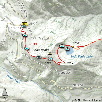
Length: 4.4 Miles round trip
Elevation Change: 700' Climb then 600' Drop = Total 1300' Gain
Season: Summer thru Fall
Difficulty: Challenging
Permit: NW Forest Pass Required
Features:
This hike begins off Forest Road #54. The
trail head is very marked. This is an
exceptionally outstanding hike. It is a
bit steep, but short enough to not matter.
The trail begins by gently climbing across
an open area before entering the forest.
Because this area outside of the wilderness
has been heavily logged you will have several
open areas with excellent views.
The trail gains about 700' before reaching
the ridge above Soda Peaks Lake. You can
see the lake below you as you look out at
the eastern Soda Peak. Now the trail descends
rather rapidly to the lake via a long circular
switchback.
When you get to the lake, it is well worth it
to walk over to the eastern side and climb a
bit up the rocky side of the east Soda Peak.
The views from there add to your reward for
coming to this beautiful little lake.
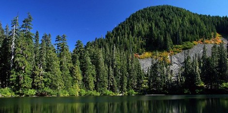
Soda Peaks Lake
|
How to get there:
NEW!
Click for PDF Directions Map of this Hike
From Portland, OR
From Portland, travel east on Interstate Hwy 84 to Exit 44 to Cascade Locks.
Exit the freeway and cross over the Columbia River into Washington
via the Bridge of the Gods. Then turn right, or east, and head
east through Stevenson, Washington to the intersection of the Wind
River Highway to Carson, Washington. Bear left onto the Wind River
Highway which will take you through Carson, Washington.
from Vancouver, WA
From Vancouver, WA travel east on SR14 through Stevenson, Washington to the
intersection of the Wind River Highway to Carson, Washington. Bear left onto the
Wind River Highway which will take you through Carson, Washington.
from Carson, WA
Continue north on the Wind River Highway (FR30) for about 8.6 miles to the
little community of Stabler and the junction with Forest Road 43, also called
Hemlock Road. Turn left onto FR43 and cross a bridge over the Wind River and
continue west for a short ways and you will come to the junction of Forest
Road 54 which is also called the Szydlo Road. Turn right and follow this road
another 3.9 miles to a junction with Forest Road 5401 which is also called Little Soda
Springs Road. Bear left and continue steeply up FR54. In another 2.7 miles
you will come to the junction of Forest Road 42, but bear to the right and
continue climbing on FR54.
FR54 will continue climbing and circling Soda Peaks to the west for another
6.8 miles. You will then come to a spur road off to your right that is very
clearly the parking area for this hike. The trailhead is labeled and you can
register for wilderness travel there.
|