How to get there:
NEW!
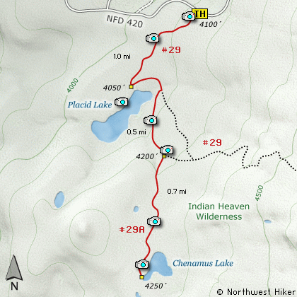
Click for PDF Directions Map of this Hike
From Portland, OR
From Portland, travel east on Interstate Hwy 84 to Exit 44 to Cascade Locks.
Exit the freeway and cross over the Columbia River into Washington
via the Bridge of the Gods. Then turn right, or east, and head
east through Stevenson, Washington to the intersection of the Wind
River Highway to Carson, Washington. Bear left onto the Wind River
Highway which will take you through Carson, Washington.
From Vancouver, WA
If however, you plan to approach this hike from the Columbia River Gorge area, then
begin at I-205 in Vancouver, Washington and head east along SR14 for about 41 miles
to the exit to Carson, WA via the Wind River Highway.
Follow the Wind River Hwy north through Carson. In 7.5 miles
you will pass through the little community of Stabler, and in another 5.8 miles you
will come to the junction of Forest Road 30. Turn right onto FR30 and follow this
road for 13.2 miles north along the Wind River and then up a steep incline and onto
a plateau where you will come to the junction of the Curly Creek Road. Continue
north on FR30 for another 5.1 miles and you will come to the junction of Forest
Road 420. Bear right onto FR420 and follow it east for a little over a mile and
you will come to the trailhead for this hike. Parking is on the left, but the
trail is across the road on the right.
|