Length: 5.8 Miles round trip
Elevation Change: 800' Elevation gain
Season: Summer thru Fall
Difficulty: Moderate
Permit: NW Forest Pass Required
Features:
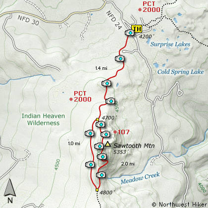
This hike begins off Forest Road #24
and follows the Pacific Crest Trail
#2000 as it heads south gently winding in and
out of lightly forested areas. At
about a half mile the trail begins to
climb more steeply and is surrounded
by dense forest.
At about a mile and a half you will
come to a junction for Trail #107.
Leave the PCT #2000 and continue on
Trail #107 as it climbs more steeply
up the north side of Sawtooth Mountain.
In a short distance you will come to
a switchback with a view of Mt Adams
and the surrounding terrain.
Continue climbing and in about another
half mile you will break out into the
open on a steep cliffy area of the
mountain. Because Sawtooth Mtn is so
steep, the trail never actually goes
to the top, but rather parallels the
ridge line as it travels south. You
are blessed with a great many wonderful
vistas along this portion of the hike.
You will see Mt St Helens to the west,
and Mt Adams to the northeast, and
Mt Hood peeking over the horizon to
the south.
Then the trail descends through a
couple of switchbacks and enters the
dense forest again. You will then
come to the junction of PCT #2000.
Take a sharp right onto the PCT and
head back north toward the trail head
where you began this hike.
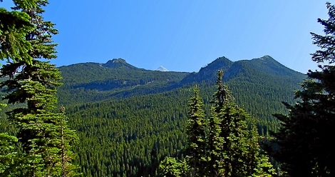
Looking south from the Sawtooth Mountain trail
|
How to get there:
NEW!
Click for PDF Directions Map of this Hike
From Portland, OR
From Portland, travel east on Interstate Hwy 84 to Exit 44 to Cascade Locks.
Exit the freeway and cross over the Columbia River into Washington
via the Bridge of the Gods. Then turn right, or east, and head
east through Stevenson, Washington to the intersection of the Wind
River Highway to Carson, Washington. Bear left onto the Wind River
Highway which will take you through Carson, Washington.
From Vancouver, WA
If however, you plan to approach this hike from the Columbia River Gorge area, then
begin at I-205 in Vancouver, Washington and head east along SR14 for about 41 miles
to the exit to Carson, WA via the Wind River Highway.
Follow the Wind River Hwy north through Carson. In 7.5 miles
you will pass through the little community of Stabler, and in another 5.8 miles you
will come to the junction of Forest Road 30. Turn right onto FR30 and follow this
road for 13.2 miles north along the Wind River and then up a steep incline and onto
a plateau where you will come to the junction of the Curly Creek Road. Continue
north on FR30 for another 5.1 miles and you will come to the junction of Forest
Road 420. Continue north on FR30 for another 5.5 miles and you will come to the
junction of Forest Road 24. Bear right onto FR24 and follow it for about a mile
and you will come to the trailhead for this hike, which is the PCT.
From Hood River, OR
From Hood River cross over the toll bridge ($2.00) on the Columbia River to the
junction with SR14. Turn left onto SR14 and drive approximately 1.5
miles to state road 141 Alt. Turn right onto SR141 Alt. and follow it another
2 miles and merge bearing left onto SR141. Then travel north on SR141
for another 19 miles to Trout Lake and the junction to Forest Road 23,
which heads north to other destinations.
from Trout Lake, WA
Bear left and continue on SR141 westbound out of Trout Lake for about
5.5 miles and you will cross into the Gifford Pinchot National Forest
and the road changes to Forest Road 24. Continue westward on FR24 for
another 2.5 miles and you will come to the junction where FR24 turns
north. Turn right and continue to follow FR24 north for another 5 miles
and you will pass the trailhead for Wapiki Lake. Continue on SR24 for
another 4 miles and you will come to Cultus Campground on your left.
Continue on for another 3.5 miles and you will come to the parking
area for this hike, where the Pacific Crest Trail crosses FR24.
|