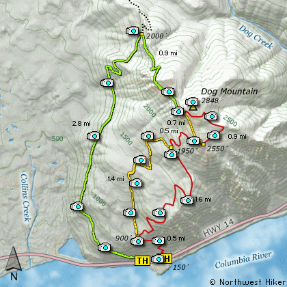
Length Red Trail: 7 Miles round trip
Length Green Trail: 7.4 Miles round trip
Length Red + Orange: 6.2 Miles round trip
Elevation Change: 2650' Elevation gain
Season: Spring thru Early Winter
Difficulty: All Routes are Difficult
Permit: NW Forest Pass Required Normally.
Special permit on weekend in peak season.
GPS: N45 41.958, W121 42.492
Latitude: 45.6993
Longitude: -121.7082
Features:
There are many combinations of ways
to climb Dog Mountain. I will discuss
three as are color coded on the above
map.
#1. The Red Trail:
The trail leaves the restroom area near
the parking lot and immediately begins
an extremely steep climb. This part of
the hike wanders in and out of forested
areas. At about a half mile you will
come to the junction of the Orange and
Red trails. Bear right and continue to
climb northeastward through fairly dense
trees and shrubs. In about another
mile the trail leaves a dense forested
area and breaks out onto a great viewpoint.
From here you have outstanding views of
the Columbia River Gorge, including Wind
Mountain to the west, and the summit of
Dog Mountain to the north. Continue on
this trail as it re-enters a densely
forested area. In about another half
mile you will come to the junction of
the Orange trail that you turned away
from earlier lower on the mountain.
At this point both the Red and Orange
trails are together during the next
half mile. This is probably the
steepest part of the entire hike. You
will then come to another junction. The
Orange hike bears to the left and up
the face of the mountain, but the Red
hike follows a more gentle approach
by switch backing its way through the
dense forest on the northeast flank of
the mountain. In a little less than a
mile you will come out just a bit short
of the top. Here you are treated to
fantastic views. Also, be aware, that
during the last week of May and the
first couple weeks of June, Dog Mountain
is the ultimate flower garden. The
Balsam Root is the main flower that
turns the mountain yellow during this
period of the year.
#2. The Orange Trail:
This option begins at the same location
as the Red trail, right beside the
restroom near the parking area.
At the half mile junction, where the
Red trail bears to the right, the
Orange Trail continues on straight
ahead. This trail is by far the
steepest approach to Dog Mtn. The
trail is almost entirely in dense
forest and at about a mile and a
half, it joins the Red trail at what
is the steepest part of either hike.
A half mile later, the two split
again, to follow the Orange Trail,
bear a sharp left and follow the
trail out in the open and up the
very face of the mountain. This
approach requires great care that
you stay on the trail and do not
get anywhere close to the drop offs
along the way. People have died by
being careless along this stretch of
the hike.
In about a half mile, after hiking
past the cliffy areas, you will come
to a junction with the Green Trail.
Here the two trails follow the same
course to the top of the mountain.
The views along this route are
exceptional and add great reward
to the hike.
#3. The Green Trail:
Now this route up Dog Mountain begins
at a different place than the other two.
Look for the Augspurger Mountain trail head
and begin the Green Trail hike from that
point. They are one and the same for the
first 2.8 miles.
The trail is steep and wanders in and out
of heavily forested areas as it climbs up
the western flank of Dog Mountain. But
all in all this is the easiest route up
Dog Mountain, and makes a great loop option
if you were to choose either the Red Trail
or the Orange Trail to return to your vehicle.
At the 2.8 mile junction, bear a sharp right
and leave the Augspurger Mtn trail and continue
on toward the summit of Dog Mountain. The
trail switchbacks its was through dense forest
for about a half mile, then breaks out onto the
south face of Dog Mountain and stays in the
open for remainder of the hike.
Not only are the views along this route
spectacular, but this route experiences the
same outstanding, breathe-taking floral
displays as the Red and Orange routes.
Just about a quarter mile short of the summit
the trail joins the Orange Trail to continue
on to the top.
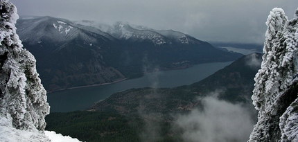
Columbia River Gorge as seen from Dog Mountain in the winter
|
How to get there:
NEW!
Click for PDF Directions Map of this Hike
From Portland, travel east on Interstate Hwy 84 to Exit 44 to Cascade Locks.
Exit the freeway and cross over the Columbia River into Washington
via the Bridge of the Gods. Then turn right, or east, and head
east through Stevenson, Washington to the intersection of the Wind
River Highway to Carson, Washington. However, just continue east
on SR14 for another 6.2 miles and you will come to the large parking
area and trailheads for both the Dog Mountain and Augspurger Mountain hikes.
From Vancouver, WA travel east on SR14 through Stevenson, Washington to the
intersection of the Wind River Highway to Carson, Washington. However, just
continue east on SR14 for another 6.2 miles and you will come to the large parking
area and trailheads for both the Dog Mountain and Augspurger Mountain hikes.
From either direction, due to overcrowding at the Dog Mountain trailhead in peak season, we highly recommend for safety that
you consider using the Skamania County Gorge West End Transit bus .
The price is low and the convenience is high.
|