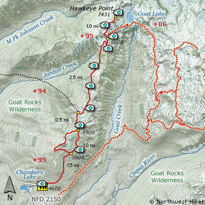
Length: 13 Mile Round Trip
Elevation Change: 3000' Elevation gain / 300' loss
Season: Mid-Summer thru Fall
Difficulty: Difficult due to length
Permit: NW Forest Pass Required
Features:
The Hike to Hawkeye Peak is one of the gems within the
incredible Goat Rock Wilderness. Try to do this hike
in Mid-July as the flowers are unbelievable.
The trail to Hawkeye is the same trail and trail head
to Goat Lake. It is located at the end of Forest Road
#2150 near Chambers Lake. Actually, the first 5 miles
of this hike are the same as the first 5 miles of the
hike to Goat Lake.
This hike to Hawkeye Peak follows Trail #95 north
along Goat Ridge. The trail head is
not the same as the trail head to Snowgrass Flats.
Follow the signs carefully when you park.
The trail begins a very steep climb immediately, and
continues to do so for the first couple miles. Actually,
you are given the opportunity to do a loop around the
Goat Ridge Lookout Trail, but on this hike, I'd
recommend just getting to Hawkeye Peak and back, so
stay to the right as you pass Trail #95A. Eventually,
you will meet the same trail again at the other end
of it. Just keep on Trail #95 heading north.
At about 2.5 miles you will past the Jordan Creek
Trail #94. Keep straight ahead, climbing again and
crossing a small stream, which could be a problem
in early summer. All along this trail you will be
treated to wildflower displays. The closer you get
to Goat Lake the better the displays.
At about 4.5 miles you will climb up into a really neat
circ. You will be out in the open from now on.
Switchbacking your way up the east side of this
area will bring you to a saddle between the two valleys
and to the Lily Lake Trail #86. Follow Trail #86
as it will take you up the ridge you will need to
climb to get to Hawkeye Peak.
The trail climbs steeply through open meadows of
incredible wildflowers (in season). As you climb
along Trail #86, the views just keep getting
better and better. Actually, they are so breath-taking
it is difficult to describe.
At about another half mile the trail reaches to top
of the ridge which you will need to follow to climb
Hawkeye Peak. At this point you are treated to
fabulous views to the north, including Mt. Rainier.
Looking up the ridge to the east of you, you can
see a users trail quite clearly. Follow this trail
to the top of the first summit just in front of
Hawkeye Peak.
When you reach this first summit, watch carefully
for mountain goats as they are plentiful in this
area. Now descend just a bit to the pass that
separates you from Hawkeye and then make the last
steep climb to the top.
As you crest the southern flank of Hawkeye, you
will be able to see Goat Lake far below you. Again,
keep you eyes open for mountain goats. As you
reach the top of Hawkeye Peak, you will be rewarded
with even more views, but now to the northeast.
With great caution you can explore the area around
the top of Hawkeye as it will provide you with
even more outstanding vistas.
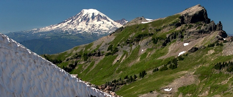
Mt Rainier rises behind Johnson Point as seen from the Hawkeye Point trail
|
How to get there:
NEW!
Click for PDF Directions Map of this Hike
From I-5 junction with US Hwy 12
Travel east on US Hwy 12 for about 48 miles to Randle.
From Randle travel east on US Hwy 12 for about 13.3 miles to the junction with
Forest Road 21. Turn right (south) onto FR21 and follow it uphill for about 5 miles.
At this point you will see Forest Road 2110 on your left, which is the road to the
Glacier Lake trailhead, but you continue straight ahead on FR21. In another 8.1 miles
you will come to the junction of Forest Road 2150. Bear left onto FR2150 and follow it
about 3 miles and you will pass the junction on your left which leads to the
Chamber Lake campground. Continue ahead just a short distance, on what is now called
FR 040 to what is referred to as the Berry Patch trailhead. This hike and many more begin here.
|