How to get there:
NEW!
Click for PDF Directions Map of this Hike
From Portland, OR
From Portland, travel east on Interstate Hwy 84 to Exit 64 at Hood River.
Turn left, and pass under the freeway and cross the toll bridge ($2.00)
into Washington state. Turn left onto SR14 and drive approximately 1.5
miles to state road 141 Alt. Turn right onto SR141 Alt. and follow it another
2 miles and merge bearing left onto SR141. Then travel north on SR141
for another 19 miles to Trout Lake and the junction to Mt. Adams Road,
which heads north to other hike destinations.
from Trout Lake, WA
Bear right and forward onto Mt. Adams Road for about 1.3 miles and you
come to the junction with Forest Road 23.
Bear right and continue on Mt. Adams Road, which is also Forest Road 82,
for another half mile or so, and when you come to Forest Road 80, bear again
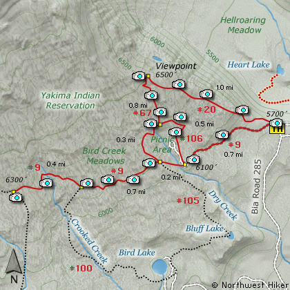
to the right and stay on FR82. To reach the Bird Creek Meadows area, just
stay on FR82 for another 8.3 miles past FR80. At this point, FR82 turns
into the Bureau of Indian Affairs Road 285 as well as FR8290.
Continue on BIA285 for another 4.2 miles and you will come to Mirror Lake
and the junction of BIA304 which takes you to Bird Lake. For the trailhead
to Bird Creek Meadows, just continue another mile and the parking area with
trailhead will be on your left.
|