

|
THE FOLLOWING MAP IS NOT TO BE USED FOR NAVIGATIONAL PURPOSES.
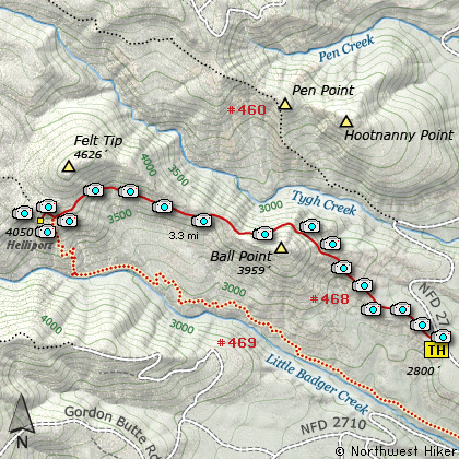
Map of the Ball Point and School Canyon Helispot Hike
|
Length: 7.2 mi RT
Elevation Change: 1400' gain
Season: Summer thru Fall
Difficulty: Challenging
Permit: NW Forest Pass Not Required
GPS: N45 17.922, W121 21.882
Latitude: 45.2987
Longitude: -121.3647
Features:
NEW!
Click for PDF Topo Map of this Hike
Here is another great hike located on the dry side of the Cascade Mountains in the
eastern portion of the Badger Creek Wilderness Area. Only a few miles west of Tygh
Valley, this enjoyable hike takes you up a ridge, behind Ball Point (yeh, that is
actually the mountain's name), and on toward Felt Tip (I'm not making this up!).
Actually, there is a mountain named Felt Tip, but this hike doesn't go to it. Somebody
from Office Depot must have named the peaks in this area, because there is another mountain
just north of there named Pen Point. Anyway, there are several reasons to drive the 100 miles
or so to check out this hike. The first reason refers to my comment about being on the dry
side of the mountains. Even if it is raining in the Willamette Valley, it might be sunny here.
Another reason to come here is the terrific spring floral display. May through June are the
best months, but even in the summer the upper end of the hike is high enough, that there are
many beautiful flowers to enjoy.
I hiked this Trail #468 in the first part of July on a hot clear day, and yet found a lot of wildflowers
still blooming, especially in the shaded areas. The trail starts out fairly level, then at about
a half mile it begins a rather vigorous ascent to the eastern shoulder of Ball Point. This provides
you with an outstanding panoramic view of eastern Oregon from north of Tygh Valley, Rock Creek
Reservoir, and south to the Three Sisters and Mt. Jefferson with Olallie Butte also clearly in view.
The trail then climbs more gently along the steep northern flank of Ball Point, which provides
considerable shade, more floral displays, and great views of the canyon and ridges to the north.
Even as you begin this hike, you will notice the charred remains of trees that were burned in the
Ball Point forest fire of July 2007. That fire burned about 700 acres and as you hike along this
trail, you will walk through a large portion of the burn. As time goes by, the burned trees begin
to fall, and thus you will have the challenge of negotiating several fallen trees, especially
while still close to Ball Point.
The further west you hike, the less fire damage you will encounter. There are many occasions
where you can catch views of the valleys below or the ridges around you, but most of the hike
is within forested areas. At about three and a half miles you will come to the junction with
Trail #469, which comes from Little Badger Creek below you. Actually, Trail #468 ends here,
and Trail #469 continues on to Flag Point. To reach the heliport viewpoint, just continue on
westward, following Trail #469 for about a fifth of a mile, and you will see a distinct trail
taking off to your left. Follow this for a few hundred feet and you will find the heliport.
This is a great place to rest, snack, and take some great photos. According to other sources,
there is a spring a few hundred feet west of this area, just off the main trail. I did not
go there, nor did I see it, but it may be a source of water if you need it.
There are a number of unusual rock formations just below you and the one to the east side can be
fun to explore. Always use mature caution as you climb off trail. Anyway, this is a great hike
and I hope you find it so.
Oh, by the way, I did come across a lot of dried cow pies, so I assume this is part of an open range
area. So, watch where you step!

Looking southeast into the valley below Ball Point
|
How to get there:
NEW!
Click for PDF Directions Map of this Hike
There are a number of ways to reach the trailhead to this hike. I choose to approach the area
from the north, by heading south from Hood River on Hwy 35. Then taking Forest Road 44 east
toward Dufur until I reached the junction with Forest Road 4420, which takes you south toward
Fifteen Mile Camp and Flag Point. However, FR 4420, cuts off to the west, and you need to then
follow Forest Road #2730 which takes you past Fifteen Mile Camp, and past FR 200 to Flag Point,
and east toward Tygh Valley. Up to this point the road is paved, but when you leave the
Mt. Hood National Forest land, the road becomes gravel. It will remain gravel until you come
to the junction with Forest Road 27.
At this point, you will need to make a very sharp right turn, onto FR 27 which will then
lead you to the School Canyon Trail #468. This is the trail to Ball Point and the School
Canyon heliport.
|
|
|
A Virtual Hike of the Mount Hood National Forest


|
|


