

|
THE FOLLOWING MAP IS NOT TO BE USED FOR NAVIGATIONAL PURPOSES.
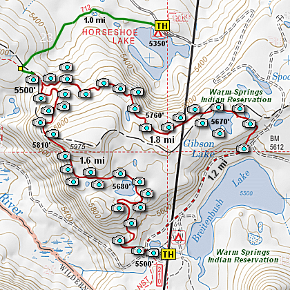
Map of the Gibson Lake Hike
|
Length: 4.6 mi Loop
Elevation Change: 700' cumulative change
Season: Summer thru Fall
Difficulty: Moderate
Permit: NW Forest Pass NOT Required
Features:
NEW!
Click for PDF Topo Map of this Hike
Here is another wonderful hike located within the south Olallie Lake Basin.
I began the hike at the PCT Trail head located near the Breitenbush Trailhead
parking lot.
I choose to present this second approach to Ruddy Hill because of the incredible
vistas you get to experience along this portion of the Pacific Crest Trai. You
begin this hike on the PCT where it crosses FR 4220, and head north in a gentle
climb. Unfortunately, there was a forest fire here a couple of hears ago, so for
the first half mile, you will walk through a burnt forest
On the bright side, with the trees all burned up, you get excellent views of Mt.
Jefferson rising higher and higer in view as you gain elevation on this portion
of the trail.
After about a half mile you will come to a beautiful little lake nestled just off
the west side of the PCT. Walk over to the edge of this lovely lake and enjoy the
view of Mt. Jefferson looming to the south.
After leaving this lake you will soon come to another pond just a short distance away.
This is a beautiful little lake and offers fine views of the ridges to the north.
After continuing on your way north on the PCT you will soon catch a glimpse of your
destination; Ruddy Hill. You cannot mistake it, as it is the only red mountain in
sight. At this point the PCT continues to climb as it makes its way along a steep
treeless slope which offers you extraordinary views of Mt. Jefferson to the south.
Soon the trail enters a forest, which very quickly turns into another burnt forest before
it turns back into a beautiful lust green forest. The trail begins a steep desent into a
saddle where you will come to the trail to Gibson Lake on your right.
The trail to Gibson Lake was built some time between 1907 and 1920 by the forest service
as part of the original Skyline Trail, which has been replaced by the Pacific Crest Trai.
Just to hike this old historic trail is fun, and the rewards are really great. However,
this trail taking you to Gibson Lake takes you into the Warm Springs Indian Reservation.
This means that if you go there, you are under the Warm Springs Indian Reservation rules
and regulations. As a curteousy and in greatfulness for being allowed to hike into this
beautiful lake, show respect to the environment and for the Warm Springs Reservation.
After leaving the PCT and heading east on the trail to Gibson Lake, this old trail begins
a moderate climb through a forested area, that soon offers outstanding vistas to the north.
On a clear day you can see Mt. Hood and Olallie Butte and Olallie Lake and Mono Lake, but
you can't see Horseshoe Lake even though you are directly above it, because the forested
hill below you blocks your view.
This trail continues to climb gently over the should of a ridge on your right, then begins
a gentle descent to Gibson Lake. There is a user trail that goes completely around the lake
and it is extremely rewarding. After enjoying the lake and its surroundings, continue
on Trail 708 until you reach the road that you will follow back to the Breitenbush Trailhead.
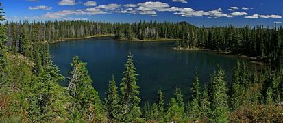
Gibson Lake in the Warm Springs Reservation
|
How to get there:
From Estacada, OR take OR-224 E/Clackamas Hwy southeast for 25.3 miles.
Then go right onto Forest Service Road 46 (This road may be seasonally closed)
and follow for 28 miles. Then turn left onto Forest Service Road 4220
and follow for about 7 miles to the Breitenbush Trailhead parking area.
Note that the last 7 miles of this approach is extremely primative road.
|
|
|
A Virtual Hike of the Mount Hood National Forest


|
|


