

|
THE FOLLOWING MAP IS NOT TO BE USED FOR NAVIGATIONAL PURPOSES.
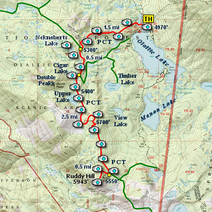
Map of the Ruddy Hill Hike
|
Length: 10 mi RT
Elevation Change: 2000' cumulative change
Season: Summer thru Fall
Difficulty: Challenging
Permit: NW Forest Pass NOT Required
Features:
NEW!
Click for PDF Topo Map of this Hike
Here is another wonderful hike located within the south Olallie Lake Basin.
I began the hike at the PCT Trail head located near the boat launch on Olallie Lake.
The first several miles of this hike are identical to the hike I present for the
south Olallie Basin. Beginning at Olallie Lake, head west on the PCT which follows
a ridge line with excellent views of Mt. Jefferson to the south.
In a mile and a half the PCT intersects Trail #719 which goes to Red Lake northwest of here.
This hike continues on the PCT, so no turns at this intersection. For those of you who are
adventurous and have a GPS that you know how to use, I have included photos of a couple of
nearby lakes that are truly worth the little effort it takes to get to them.
The first off trail lake is called Ring Lake and the larger more distant lake is called
Neknoberts Lake. They are well worth the effort to find them, but remember that there
is no trail leading to either of them.
Anyway, after this possible detour, continue south on the PCT for about a mile and you will
come to another junction. Bear to the right and keep on the PCT. The trail to the left
heads downhill and to Top Lake. You will skirt the southern shore of Cigar Lake, which
I happen to believe is one of the most picturesque lakes in the basin.
After Cigar Lake it is another 3/10ths of a mile to Upper Lake. This lake provides a great
place for lunch or for a snack break, or if you are so inclined a place to camp overnight.
Whether or not you stop, eventually you need to continue south on the PCT. In about 3/4
of a mile, the trail will have passed a large open meadow and climbed to a viewpoint.
The trees have grown quite high and the view is not very good, but you can catch a glimpse
of Mt. Hood to the north and Olallie Butte to the northeast.
The trail then looses the elevation you just gained and continues south toward Ruddy Hill.
In another mile or so you will come to the junction of the trail that takes you to the
summit of Ruddy Hill. The trail is well marked, but the climb is very steep. The fact
that it is only a half mile to the top makes it tolerable.
From the summit of Ruddy Hill you have fantastic views of Mt. Jefferson rising up behind
Park Ridge. Pyramid Butte is just across the canyon and doesn't look all that high from
this vantage point.
The benefits of hiking to Ruddy Hill from Olallie Lake are all the little lakes along the way
and the great views of Mt. Jefferson. The shorter but much steeper approach from the
Breitenbush Trailhead is more popular. Nevertheless, enjoy this route.
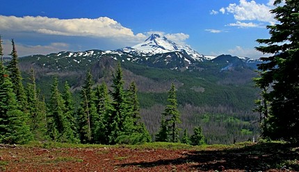
View of Mt. Jefferson from Ruddy Hill
|
How to get there:
Follow Highway 224 out of Estacada for about 26 miles. Right after the bridge just beyond the Ripplebrook Station,
bear right and continue on Road 46 for another 21 miles. Watch for the paved Road 4690 on your left, and take it
for about 8 miles to the junction to gravel Road 4220. Turn right and follow this road for about five miles. Just
before the junction to the Olallie Lake Resort, the PCT2000 crosses the road. Park here for this adventure.
|
|
|
A Virtual Hike of the Mount Hood National Forest


|
|


