Length: 11.5 mile loop trip
Elevation Change: 2270' gain
Season: Late Spring thru Fall
Difficulty: Challenging
Permit: NW Forest Pass Required
Features:
NEW!
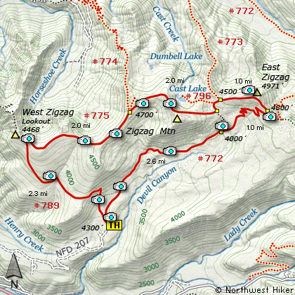
Click for PDF Topo Map of this Hike
This hike begins by first hiking to Burnt Lake which is an extremely
popular hike. The hike begins as a gentle walk through a dense rain-forest type
environment. Then at two miles the trail makes its only major switchback and becomes much
steeper. The trail climbs this last mile out of the dense forest and into a
more open area with occasional views of the surrounding hills and Mt Hood.
The trail travels around Burnt Lake however to reach East Zig Zag Peak you need
to take the trail to the right about a quarter mile around the west side of the lake.
Follow this well maintained trail through a swampy are before beginning a moderate
climb up the face of Zig Zag Mountain.
At the top of the ridge you will intersect
Trail #775 which to the left goes to Mt Hood. Continue straight ahead following
Trails #772 and #775 up a very steep but short climb to the open area of the ridge.
From this point on the views are incredible.
As you continue westward along this ridge Trail #772 will make a left turn off the
ridge. You continue straight ahead on Trail #775 to the summit. From this vantage
point you will have unobstructed 360 degree views. You can look down on Burnt Lake;
east to Mt Hood; southeast to Mt Jefferson; northwest to Mt St Helens; north to
Mt Rainier; and northeast to Mt Adams.

Mt. Hood as seen from the Zig Zag Mountain trail
|
How to get there:
NEW!
Click for PDF Directions Map of this Hike
Follow Hwy 26 about 1.4 miles east of
Rhododendron to Road 2627 located on
the north side of the highway and just
before a bridge. Follow this paved road
for about a half mile and it makes
an extremely sharp left turn and becomes
Forest Road 207. The road becomes graveled
and is in very poor condition and climbs
steeply at times. In about
4 miles you will reach a nice parking
area for the trailhead.
|
|