

|
THE FOLLOWING MAP IS NOT TO BE USED FOR NAVIGATIONAL PURPOSES.
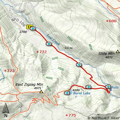
Map of the Burnt Lake Hike
|
Length: 6 miles round trip
Elevation Change: 1400' gain
Season: Late Spring thru Fall
Difficulty: Moderate
Permit: NW Forest Pass Required
Features:
NEW!
Click for PDF Topo Map of this Hike
The Burnt Lake hike is extremely popular and for a good reason.
This hike begins as a gentle walk through a dense rain-forest type environment.
Then at two miles the trail makes its only major switchback and becomes much
steeper. The trail climbs this last mile out of the dense forest and into a
more open area with occasional views of the surrounding hills and Mt Hood.
The trail travels around Burnt Lake and there are many places where you can
access the shoreline for excellent view (and some fishing if you're interested).
If you stay over night, be sure to stay in designated areas.
For a bit of variety, either on your way up or on your way back down from Burnt Lake,
you might be interested in taking a very short side trip to a fun little waterfall.
The trail that leads to the falls is on the downhill side of the only major switchback
on the trail to Burnt Lake. See the map above for reference to the falls.

Mt. Hood rises above Burnt Lake
|
How to get there:
NEW!
Click for PDF Directions Map of this Hike
Follow US Highway 26 through Welches to Zig Zag.
Turn north (left) onto the Lolo Pass Road (road 18) at
Zig Zag (across Hwy 26 from Zig Zag Pizza). Follow the road for 4
miles. Turn east (right) onto Road 1825 and continue for .6 miles.
Turn right across a bridge over the Sandy River and continue another
1.7 miles to the junction to Lost Creek Campground. Bear right,
and follow the road another .3 mile toward the campground, but just
before the campground, bear to the left and follow Road 1825 another
.4 mile where you need to bear right and follow Road 109 up the hill and
to the Burnt Lake Trailhead parking area.
|
|
|
A Virtual Hike of the Mount Hood National Forest


|
|


