

|
THE FOLLOWING MAP IS NOT TO BE USED FOR NAVIGATIONAL PURPOSES.
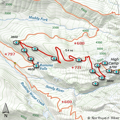
Map of the Yocum Ridge Hike
|
Length: 18 mi RT
Elevation Change: 4600' gain
Season: Late Summer thru Early Fall
Difficulty: Extreme
Permit: NW Forest Pass Required
Features:
NEW!
Click for PDF Topo Map of this Hike
This is very likely the most challenging of all the hikes on my Mt. Hood CD. What makes this
hike special is that it is so remote. I've done the hike twice and neither time did I yet own
a digital camera, so my photos are not very presentable. Nevertheless, I just couldn't leave
this special hike off this new CD and I hope you still appreciate and enjoy what I can present.
The hike to Yocum Ridge begins just as if you were going to Ramona Falls. You start at the same
trailhead parking area and walk along the Sandy River until you reach the place where the Forest
Service sets up its temporary summer crossing.
As with the hike to Ramona Falls, you have two choices after crossing the Sandy River as to how you get
to the junction to Yocum near the falls. Which ever way you choose to reach Ramona, just to the west
of the bridge over the creek that creates the falls, is the junction that used to be the Pacific Crest
Trail and Trail #797 which you have used to reach this point. I assume the trail is now referred to as
Trail #600, or the Timberline Trail which goes completely around Mt. Hood.
It is a little over a half mile climb up Trail #600 to the junction of Trail #771, which is the Yocum
Ridge trail. Follow this trail as it climbs through heavily forested areas for about a mile and you
will come to a stand of very large old growth trees. They are very impressive. Just after this the
trail begins to switchback as it climbs steeply for another mile and a half. The trail skirts a small
tarn but it doesn't appear safe to drink.
In another half mile you will come to a small creek, which might be your last chance at good water,
depending on the time of year you are hiking. As you continue to climb about another mile or so,
you will break out into open areas with spectacular views of Mt. Hood and the Zig Zag River Canyon below you.
The trail switchbacks to the west and takes you around the ridge itself and onto the north face. Again,
depending on what time of year you hike this, there could be alot of snow. The actual trail pretty much
ends here, but the area is so open that you can continue to climb up along the ridge toward Mt. Hood for
at least another mile.
It is very likely that you will find drinkable water on this north face as you make your way up to the more
level areas just in front of Mt. Hood itself. I camped at this spot by just rolling my sleeping bag out
on the ground and basking in the fantastic beauty around me. You will most likely hear rocks and ice falling
from the mountain as the summer melt continues. I wouldn't go much further than this open and comparatively
level area because of the danger of rock/ice fall.

Mt. Hood from Yocum Ridge trail
|
How to get there:
NEW!
Click for PDF Directions Map of this Hike
Follow US Highway 26 through Welches to Zig Zag.
Turn north (left) onto the Lolo Pass Road (road 18) at
Zig Zag (across Hwy 26 from Zig Zag Pizza). Follow the road for 4
miles. Turn east (right) onto Road 1825 and continue for .6 miles.
Turn right across a bridge over the Sandy River and continue another
1.7 miles to the junction to Lost Creek Campground. Bear left, do
not follow the road to the campground, but instead follow Road 100
approximately .3 miles to a large parking area. The trailhead is
located on the east side of this parking area. This is the trailhead
for both Ramona Falls and Yocum Ridge.
|
|
|
A Virtual Hike of the Mount Hood National Forest


|
|


