

|
THE FOLLOWING MAP IS NOT TO BE USED FOR NAVIGATIONAL PURPOSES.
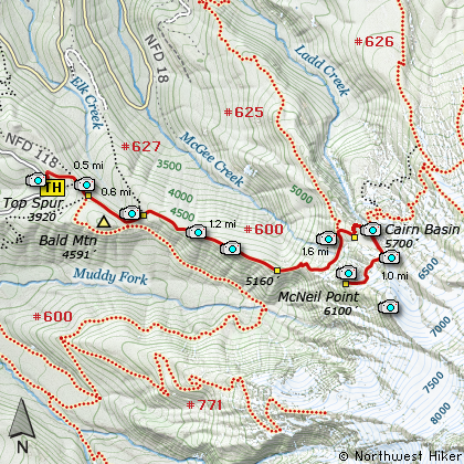
Map of the Top Spur, McNeil Shelter, McNeil Point Hike
|
Length: 9.8 miles round trip
Elevation Change: 2180' gain
Season: Early Summer thru Late Fall
Difficulty: Challenging
Permit: NW Forest Pass Required
Features:
NEW!
Click for PDF Topo Map of this Hike
This hike begins at the Top Spur cutoff Trail #765. After a half mile climb
you intersect the Pacific Crest Trail #2000. Follow this trail for a couple hundred feet to the
right where you come to a major intersection of four (4) trail options. Select the trail
immediately to your left, Timberline Trail #600. Follow this trail for about another two
miles and you will come to a popular viewpoint of the Sandy Glacier on Mt Hood with the
Muddy Fork river valley below.
Continue up the ridge to a series of switchbacks that offer you on again off again views of
the surrounding hills and valleys. At about three and a half miles you will come to a small
basin with a couple of ponds. The upper pond on your left offers the best views of Mt Hood.
A short distance past this pond you will come to the intersection of the Mazama Trail.
Continue on about a quarter mile and the trail turns sharply to the left crossing a small
seasonal creek.
The route to McNeil Point used to continue up this small valley toward Mt Hood, but has
recently been closed to for restoration. So, just continue on the trial toward Cairn Basin
and in about another half mile you will come to the signed junction of the new route to
McNeil Point.
Follow this trail which in season is a floral paradise to the old shelter on McNeil Ridge.
An additional challenge awaits those who would like to climb up the very steep slope to
McNeil Point another 800+ feet above the shelter. Regardless, you will have already hiked through
some of the most beautiful natural surrounds that the Mt Hood area has to offer.

Mt. Hood rises above McNeil Point
|
How to get there:
NEW!
Click for PDF Directions Map of this Hike
Take the Lolo Pass Road (Road 18) out of Zig Zag
for about 4 miles. Bear right on Road 1825. In
about another mile, bear to the left and do NOT
cross the bridge over the Sandy River. Follow
Road 1828 about 6.5 miles to the junction with
Road 118. Bear right on Road 118 and follow it
another couple miles to the trailhead. Park head-in
on the opposite side of the road from the trail.
Vandalism is a problem here... so be aware.
Note: This is the same trailhead for McNeil Point,
and the Bald Mtn. Overlook hikes. You can also hike
to Cairn Basin from here.
|
|
|
A Virtual Hike of the Mount Hood National Forest


|
|


