|
THE FOLLOWING MAP IS NOT TO BE USED FOR NAVIGATIONAL PURPOSES.
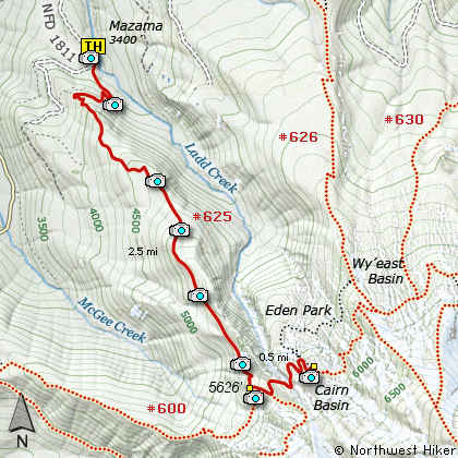
Map of the Mazama Trail, Cathedral Ridge, Cairn Basin Hike
|
Length: 6 miles round trip
Elevation Change: 2300' gain
Season: Early Summer thru Late Fall
Difficulty: Difficult
Permit: NW Forest Pass Required
GPS: N45 26.230, W121 45.434
Latitude: 45.437167
Longitude: -121.757233
Features:
NEW!
Click for PDF Topo Map of this Hike
This excellent hike is listed as difficult because of the vigorous climb that
is required to reach the junction of the Mazama Trail and the Timberline Trail.
Nevertheless this adventure is worth every muscle aching, lung gasping, mosquito
infested step of the way..... only kidding, its really not that bad, and it truly
worth whatever effort required to reach Cairn Basin in summer or fall.
I say fall, because I've included some photos of the area taken in the fall, which
will show you just how beautiful that season is at Cairn Basin.
Back to the hike.... So, after you've parked your comfortable SUV at the spacious
trail head parking lot, the trail wanders mostly level for a bit, kinda giving you
a false sense of what's ahead. Soon you reach the Forest Service sign in "booth"
and you're on your way. The trail begins by climbing abruptly through a large
rocky area. Here you get lots of views of the surrounding area, especially the
shrinking size of that SUV you left behind at the trail head.
The only significant difference in the trail environment as you climb the Mazama
Trail is altitude. You will wander in and out of dense forests, Rhododendron lined
pathways, and Avalanche Lily gardens.... if the season is right. Otherwise you
just wander.
After reaching the Timberline Trail, bear left and follow the trail another half
mile to Cairn Basin. In season the trail passes through incredible fields of
Paintbrush, Lupine, and other alpine flowers that can leave you with an entire
roll of pictures of just flowers. There are also lots of views. Other than one
of the most superb views of Mt Hood, there are many vistas that you will want
exposed on your camera's collection format; ie film or CCD.... anyway you look at
it or photograph it, this hike is truly worth it.
By the way, the Mazama Trail is named after the outstanding organization that does
a true labor of love by maintaining this trail in excellent condition! If you
know a member, thank them.

Stone storm shelter at Cairn Basin
|
How to get there:
Follow US 26 three miles east of the Mt Hood
Information Center in Welches. Turn left
(north) on the Lolo Pass Road (Road 18) at
Zig Zag (across from the Zig Zag Pizza).
Follow this road to Lolo Pass which is
about 9 miles. Then turn right onto the
gravel portion of this highway.
Follow the gravel road for about 4 miles
and it will turn back into a paved road.
It is at this point, that you bear to the
right and drive up Road 1811 until you
reach the well marked trailhead for the
Mazama Trail up Cathedral Ridge.
|
|
|
A Virtual Hike of the Mount Hood National Forest


|
|