

|
THE FOLLOWING MAP IS NOT TO BE USED FOR NAVIGATIONAL PURPOSES.
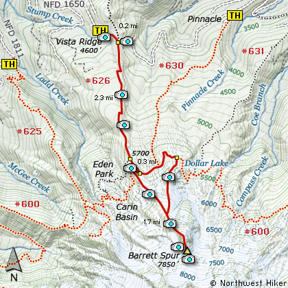
Map of the Barrett Spur, Vista Ridge, Wyest Basin, Dollar Lake Hike
|
Length: 9 miles round trip
Elevation Change: 3250' gain
Season: Late Spring thru Fall
Difficulty: Difficult - Dangerous
Permit: NW Forest Pass Required
GPS: N45 26.574,W121 43.752
Latitude: 45.4429
Longitude: -121.7292
Features:
NEW!
Click for PDF Topo Map of this Hike
This hike begins at the Vista Ridge trail head. The first 2.5 miles
of the hike are mostly in dense forested areas. The trail is in excellent condition and
follows Vista Ridge to the beautiful Wy'east Basin. You will intersect Trail #600H which
leads to Eden Park.
Continue straight ahead where you leave the forested areas and are
treated to incredible vistas and seasonal floral displays. When you intersect Trail #600,
make the sharp right turn and follow this trail to the top of the exposed ridge.
From there the hiker must scramble up Vista Ridge by following the path left by other hikers.
The last mile and a half of this hike is very steep and can be dangerous during certain
times of the year, so extreme caution is urged. The rewards of this hike are incredible.
During the summer months, Wy'east Basin is a gorgeous flower garden and the climb up Barrett
Spur is lined with all manner of floral displays. The inclusion of this hike
in my website is not an attempt to get hikers to climb Barrett Spur, but instead an
attempt to provide the hiker with the necessary information to make the climb
successful and without danger. The last half mile as one ascends Barrett Spur
the rocks are very unstable and the cliffs can be dangerous.
When you descend Barrett Spur and begin the hike back down keep to the right and follow
the user trail to Dollar Lake. After the lake you will quickly connect with Trail #600.
Follow the Timberline Trail (#600) back to Trail #626 which you used to reach Wy'east Basin.
Turn right onto Trail #626 and follow it back to the Vista Ridge Trail head.

Mt. Hood looms above Barrett Spur
|
How to get there:
NEW!
Click for PDF Directions Map of this Hike
To reach this trailhead from Hood River, follow
the sign for old US Hwy 30 into town. From the
west turn right on 13th Street and follow it up the
hill until it merges with 12th. If you are approaching
from the east, on US 30, turn left on 9th and follow it
up the hill until it merges with 12th. Either way,
follow 12th south out of town on what is called
Tucker Road or Hwy 281. About 6 miles out of town you
will cross the Hood River. Immediately after the bridge,
bear right and pass Tucker Park. In about another
six miles you need to bear to the right again following
signs to Lost Lake. This community is referred to as Dee.
As soon as you cross the railroad tracks, bear left and follow the signs to
Lost Lake. This paved road becomes Forest Road 18, and
you need to follow it about another 8.5 miles.
At this junction, turn left and continue on Road 18 for
about 4 miles. You will come to Road 16 on your
left. Turn left and follow this road for about another
4 miles as you climb out of the canyon. You
will then come to Road 1650 and a sign indicating
Vista Ridge. Make a hard right turn onto this
road and follow this road for about 3 miles to its end.
To approach this trailhead from Zig Zag, follow Hwy 26
to Zig Zag and turn north on the Lolo Pass Road (Road 18).
Follow the road over the pass. Turn right onto the
gravel part of this road which is not well labled. This
intersection (N45 25.644, W121 47.787)is critical because if
you go straight on
Lolo Pass Road you will encounter the McGee Creek Crossing
which requires a high ground clearance vehicle. So turn
right past a trail-head with the PCT on NF-1811 (McGee Crrek Road)
and continue on for several miles until it returns to pavement.
Drive about another 5 miles and you will come to a labled Road 16 on your
acute right (N45 30.082,W121 44.528). Make a hard right turn
(N45 28.462,W121 44.416) and follow this road
uphill to Road 1650. Make another hard right turn
onto this road and follow it to the trailhead on left.
|
|
|
A Virtual Hike of the Mount Hood National Forest


|
|


