

|
THE FOLLOWING MAP IS NOT TO BE USED FOR NAVIGATIONAL PURPOSES.
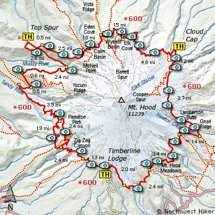
Map of the Timberline Trail Hike
|
Length: 39.8 mile loop
Elevation Change: High Point = 7300' Low Point = 3200'
Season: Summer thru Fall
Difficulty: Very Difficult due to length and elevation changes
Permit: NW Forest Pass Required
Features:
NEW!
Click for PDF Topo Map of this Hike
The Timberline Trail #600 is an excellent trail that circles Mt. Hood at or near
timberline, thus its name. The exact mileage of the trail varies a bit, but it
is very near to 39 miles. The trail is almost always very well maintained and in
safe condition to hike. The only significant challenge on this trail is the water
crossings. Depending on the time of year, the various run-off rivers and creeks
that flow across this trail vary greatly. Make no doubt about it, the crossing
of these streams can be very dangerous and caution is absolutely essential.
A hiker can choose his direction of walking the Timberline Trail. Most people
seem to favor beginning at the Timberline Lodge parking lot and hiking west, or
clock-wise. The hike is best done in three days, thus requiring two overnight
stays along the trail. This narrative is not meant to offer a complete detailed
report as to the best places to camp and other various nuances of the hike, but
is intended to simply illustrate the trail for the potential hiker.
You are strongly encouraged to obtain books that detail the hike and give you the
necessary tips to make the journey an enjoyable adventure. Contact the forest
service or a local book store to find this information.

Crossing the Muddy Fork drainage below Mt. Hood
|
How to get there:
NEW!
Click for PDF Directions Map of this Hike
Follow US 26 to Government Camp. Turn north
on Road 50 to Timberline Lodge. Park in the
designated parking area when you arrive.
The trails are located behind the lodge and
up a paved service road about a couple hundred
yards.
Note: This is the same trailhead for the Timberline Trail,
the Paradise Park Loop hike, and the East Zig Zag Overlook Hike.
|
|
|
A Virtual Hike of the Mount Hood National Forest


|
|


