

|
THE FOLLOWING MAP IS NOT TO BE USED FOR NAVIGATIONAL PURPOSES.
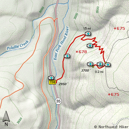
Map of the East Zig Zag Trail Overlook Hike
|
Length: 3.4 miles round trip
Elevation Change: 900' gain
Season: Late Spring thru Fall
Difficulty: Moderate
Permit: NW Forest Pass Required
Features:
NEW!
Click for PDF Topo Map of this Hike
This is an outstanding little hike with immense rewards. The trail used to begin at
the Polallie Trail head, but mother nature took care of that idea some time ago. Now
you need to go a bit further upstream where Hwy 35 crosses the East Fork of the Hood
River, and you'll see the trail head sign off to the east side of the road. Not much
area to park, but normally adequate.
Because the trail head was relocated, the trail is new for about the first half mile.
You actually loose a bit of elevation at first, then after you pass where the old
trail begins, you start a very vigorous climb, thus the hike may be short but definitely
moderate in difficulty.
As you climb the ridge you will be offered a variety of environments. You'll be in
dense forest one minute, then in the open the next where you have a brief view of
the cliffs around you. But it is not until you reach the top that you receive your
true reward. When you summit, you'll be at an intersection of Trails #678 and #675.
You will follow neither of these to your destination. Instead follow the small path
referred to by a sign entitled "View". You will loose altitude now, as you descend
to the vantage point where you will have spectacular views of Mt Hood and Mt St Helens
to the north. Highway 35 is below you.

Mt. Hood seen from the East Zig Zag overlook
|
How to get there:
NEW!
Click for PDF Directions Map of this Hike
Follow Oregon Hwy 35 south of Hood River
until you come to the Cooper Spur Resort
access road. Just past this junction,
and just past the Polallie Trailhead,
and just over the bridge on the left
side of the road is the trailhead for
this hike.
If you are coming north on Hwy 35
from Hwy 26 near Government Camp, drive
until you come to the Sherwood Campground
and the Tamanawas Falls trailhead, then
watch on the right side of the road just
before you cross the river and you will
see the trailhead for this hike.
|
|
|
A Virtual Hike of the Mount Hood National Forest


|
|


