Length: 7.8 miles round trip
Elevation Change: 3200' gain
Season: Late Spring thru Fall
Difficulty: Difficult
Permit: NW Forest Pass Required
Features:
NEW!
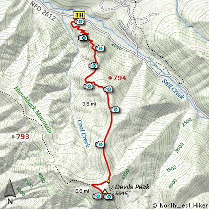
Click for PDF Topo Map of this Hike
Did I say difficult? Oh, I guess I did. Well, if you survive the first 100 feet of
this rugged little stroll, you'll survive the whole thing. Talk about steep right
out of the starting gate. No warm up time here!
Well, Don't let those little details worry you. Here's a hike to gasp air by. Yes,
a real coronary challenge. But if you're up to it, well, let just say, this is a duzy.
After the first hundred feet or so, if you find yourself still standing, then you've got
it made. Just keep up the good work, and try to enjoy the view through your sweat stained
eyeballs.
The trail wanders through densely populated forested areas with an occasional peek out
at the rest of the world. Actually, about a mile into the hike you get several great
opportunities to view Mt Hood and the surrounding landscape, that is if your vision
hasn't blurred from the flood of saline solution flowing over your visual orbs.
Then its back into the woods for another mile or so. The next opportunity to view
Mt Hood and the valley below is actually just a few staggers, I mean steps, off the
beaten path. It is obvious where others have worn a path to the viewpoints as an excuse
to catch their breathe before losing conscienceness.
Then back to the torture, I mean hike. You've gained enough altitude now that the
trees begin to thin a bit and you hike along a rugged rocky area. This is quite
floral in the springtime. Soon you come to the junction of Trails #794 and #793.
Bear right at this point for a short walk to the spur trail that takes you to the
summit of Devil's Peak (apt name for sure). Turn to your left and follow the spur
trail about a quarter mile and there you are.... face to face with a real live fire lookout.... reconditioned
and such. With the right arrangements you can even stay in it... if for some reason
you would want to do a thing like that. Nevertheless, enjoy the vistas and rest up
for the hike back down the mountain.
Did I mention how steep this hike is? Remember to use caution when going back down.
Sometimes it's harder to go down steep areas than it is to go up.

Lookout on the summit of Devils Peak
|