

|
THE FOLLOWING MAP IS NOT TO BE USED FOR NAVIGATIONAL PURPOSES.
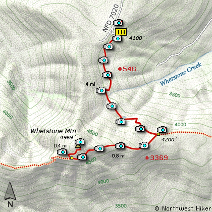
Map of the Whetstone Mountain Hike
|
Length: 4.6 mi RT
Elevation Change: 1069' gain
Season: Summer thru Fall
Difficulty: Moderate
Permit: NW Forest Pass Not Required
Features:
NEW!
Click for PDF Topo Map of this Hike
This hike shares the same trailhead as the western approach to Twin Lakes and the hike
to Silver King Lake.
The first mile and a half are exactly the same trail, but when you climb up onto the
ridge, and come to the junction to Trail #3369, bear a sharp right and follow this
trail to the base of Whetstone Mountain. As you leave the trailhead parking area,
the trail descends into a forest of large, probably old growth timber. Depending on
the season, it can be damp through this part of the hike, but the trail soon climbs
in a series of steps to higher, drier ground.
Although you will come upon a small tarn, there are few water sources to negotiate. After
the tarn, the trail climbs rather steeply until it reaches the junction of Trail #3369. As
mentioned, bear a sharp right onto Trail #3369 and head west along the ridge toward Whetstone
Mountain.
Trail #3369 actually goes all the way to the North Fork of the Santiam River at the bottom of the canyon, but you will
only want to follow it as far as the junction to the trail that takes you to the summit of
Whetstone Mountain. The trail climbs steadily along the ridge and wanders through mostly dense
forests of fir and hemlock. It is less than a mile from the junction to the next junction,
which connects to the summit trail. Bear right and follow the steep incline through a series
of switchbacks and occasional viewpoints until you reach the summit. As is common, this
mountain also once had a fire lookout on top of it and the foundation is still there.

Looking east toward Mt. Jefferson from
the summit of Whetstone Mountain
|
How to get there:
NEW!
Click for PDF Directions Map of this Hike
Follow Hwy 224 southeast of Estacada approximately 25 miles until it becomes
Forest Road 46 just after the Ripplebrook Ranger Station and the junction with
Forest Road 57. Continue south for about another 3.7 miles to the junction
with Forest Road 63. Bear right onto FR 63 and cross over the Clackamas River.
The road now follows the Collawash River for approximately 3.5 miles until you
come to the junction with Forest Road 70.
Turn right onto FR 70, which is the same road that takes you the Bagby Hot Springs area.
Continue for approximately 6.5 miles past the Bagby Hot Springs parking area
to the junction with Forest Road 7020. Turn left onto FR 7020 which will take you
steeply up a rather rough road. At times you might think that you are on the wrong
road. Actually, you might wonder if you are on a road... but be assured, it gets
better. It is about 5.5 miles to the trailhead. Just before the trailhead
you will pass the junction to Forest Road 7030, but keep straight ahead.
|
|
|
A Virtual Hike of the Mount Hood National Forest


|
|


