

|
THE FOLLOWING MAP IS NOT TO BE USED FOR NAVIGATIONAL PURPOSES.
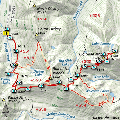
Map of the Big Slide Mtn and Lake Lenore Hike
|
Length: 12.8 mi RT
Elevation Change: 3518' gain
Season: Summer thru Fall
Difficulty: Very Difficult
Permit: NW Forest Pass Not Required
Features:
NEW!
Click for PDF Topo Map of this Hike
The trailhead begins at Forest Road #6341. This is the same trailhead you would use to
hike to Bull of the Woods Mountain or just to Pansy Lake.
You begin a gentle climb through large standing
timber, no doubt old growth. The trail crosses several small streams and is often lined
with the wonderful Rhododendron. At about a mile you come to the junction to Trail #549.
To reach Bull of the Woods Mountain you would bear left on Trail #549, but for this hike
continue on straight ahead toward Pansy Lake.
At about a mile and a half you will come to a small trail breaking off to the right which
takes you to the Pansy Lake shoreline. As long as you are here, it would be a shame to
not take a few moments to drop down to the lake to enjoy its unique beauty. Settled in a
small cirque, the lake is surrounded by beautiful forested hills all around. After this
brief detour, head back to Trail #551 and continue south, climbing your way through a series
of switchbacks to the junction with Trail #558. As you climb toward the saddle, there
will be a couple of opportunities to view Pansy Lake below. You may have to walk off the
trail just a few feet to catch you best views, but it is truly worth it.
At the saddle junction, bear left or east onto Trail #558 and follow this trail to the next
junction. This part of the hike offers some spectactular views of Mt. Jefferson to the southeast,
but it will get incredibly better as you near Big Slide Mountain itself. Also, along this part
of the trail I have found the beautiful Blue Flax Wildflower and the fiery red Scarlet Gila or
Rocket Flower. In season there are a lot of beautiful wildflowers along this entire hike.
In a couple of miles you will come to the junction of Trail #554. Bearing a sharp left on
this trail will take you to the summit of Bull of the Woods Mountain, so for this hike, you
want to continue on to the right, or east. You will follow Trail #554 only a short distance
as you climb your way to the next junction of Trail #555. This is the trail that will take you
to Big Slide Mountain, so bear left and head downhill. You will drop rather steeply into
a saddle that rests between the trail to Big Slide Lake, Big Slide Mountain, and Welcome
Lakes.
At the bottom of this descent you will first come to the junction of Trail #553 which is the
trail to Big Slide Lake. Continue straight ahead. Very soon you will come to the junction
with Trail #554 which is the trail to Welcome Lakes. Remain on Trail #555 by continuing
straight ahead. Soon you will begin a series of switchbacks that will begin the climb up
Big Slide Mountain. As you climb out of the saddle, your view opportunities will multiply.
Behind you is Bull of the Woods Mountain and you can clearly see the lookout tower on top
of it.
Below you is West Welcome Lake, and in the distance to the southeast is Mt. Jefferson.
The trail along this section was pretty overgrown in areas as we climbed it in the summer
of 2010. However, it was never difficult to find or follow and the views just kept getting
better and better. The summer wildflowers along this stretch were magnificent. Another
mile or so in the climb, as you come out into an open area, you can tell that the ridge
just to your left is a place to explore, so leave the trail and climb the short distance
to a wonderful viewpoint. The summit of Big Slide Mountain is right there on your right,
while the Dickey Creek valley and surrounding hills are visible to the northwest.
Find your way back down to the main trail and continue east. The views of Mt. Jefferson
to the souteast just keep getting better and better. Other peaks are apparent too. The
wildflowers get better and better and soon you will come out in an open area with a junction
to a trail that leads down to Lake Lenore. A user trail continues on to the east past
Knob Peak to Schreiner Peak. However, to reach the summit of Big Slide Mountain, you
have decisions to make.
There is no trail as such to the summit of Big Slide Mountain. Actually, I don't encourage
you to do so, only because it is not easy, nor completely safe. However, if you insist on
getting there, just use your own good judgement and bushwack your way to the top. We did,
and I survived. The views are wonderful, and the view of Lake Lenore a thousand feet below
you makes it almost impossible to resist. So, after a rest, why not take the plunge.
Make your way back to that saddle below you where the trail heads down to Lake Lenore and
treat yourself to an extremely steep descent, which of course you must crawl back up in order
to sleep in your own bed tonight.

Mt. Jefferson as seen from
the Big Slide Mountain trail
|
How to get there:
NEW!
Click for PDF Directions Map of this Hike
Follow Hwy 224 southeast of Estacada approximately 25 miles until it becomes
Forest Road 46 just after the Ripplebrook Ranger Station and the junction with
Forest Road 57. Continue south for about another 3.7 miles to the junction
with Forest Road 63. Bear right onto FR 63 and cross over the Clackamas River.
The road now follows the Collawash River for approximately 3.5 miles until you
come to the junction with Forest Road 70.
Continue on FR 63 for approximately 2.2 miles and on your right Forest Road 6340
will veer off and uphill. Follow FR 6340 for about 7.8 miles to the junction with
Forest Road 6341. Bear right onto FR 6341, which ironically is paved. Continue
on for about another 3.6 miles and as the road crosses a creek, veering to the right,
you will see the trailhead sign and parking on the right side of the road.
This is the same trailhead for Pansy Lake, Bull of the Woods Mountain, Big Slide Mountain,
Lake Lenore, and Welcome Lakes.
|
|
|
A Virtual Hike of the Mount Hood National Forest


|
|


