| Hike 88 |
 |
|
|
|


|
THE FOLLOWING MAP IS NOT TO BE USED FOR NAVIGATIONAL PURPOSES.
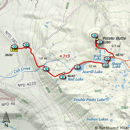
Map of the Potato Butte Hike
|
Length: 7.4 miles round trip
Elevation Change: 1680' gain
Season: Summer thru Fall
Difficulty: Challenging
Permit: NW Forest Pass Required
Features:
NEW!
Click for PDF Topo Map of this Hike
Beauty for the buck, it doesn't get much better than this hike. First of all, you can
drive your vehicle on paved road almost to the doorsteps of this hike. Second of all,
it's an easy climb and a wonderful hike through a high lake basin surrounded by white
pine and mosquitos.... oops, there I go again. Oh, well, every hike has its down side.
So lather up, and let's hike to Potato Butte. The trail begins to climb immediately,
but not until you reach the Potato does it really get steep. You hike mostly in
a forested environment until you reach the basin at about a mile and three quarters.
Here things level off a bit and you soon come to the first lake, Red Lake. You need
to leave the main trail to your right and follow user trails to the lakes edge.
From here you get glimpses of Mt jefferson and Double Peaks. This
is one of many beautiful lakes nestled in the forests of the Olallie Basin.
To continue your journey, make your way back to the trail and head east. In about a
half mile you will come to the next lake, Averill Lake. I really like this one. Its
color and setting is really nice. You can catch a glimpse of Olallie Butte to the
east and Double Peaks to the southeast. Back to the trail.
Its only about another half mile to the next lake, Wall Lake. Unlike the first two
lakes, the trail follows along the south side of this lake, giving you the first view
of your destination, Potato Butte. Boy, it sure doesn't look tall from this lake.
Oh well, looks are deceiving. The trail continues on past Wall Lake.
In only about a quarter mile you come to the last of this series of lakes, Sheep Lake.
This is also a very lovely lake, and you get a better view of Olallie Butte from here.
Fortunately, there is a sign nailed to a tree indicating which way it is to Potato Butte.
Follow the sign, and follow the path. You will wander through fairly open marshy areas
until you get to the base of Potato Butte. Along the way, there is one pond that
throws a great photo opt for Mt Jefferson which is trying to make an appearance.
Now the real climbing begins. I hope you've hydrated well, because the maker of this
trail forgot one little word..... switchback.... there aren't any. The trail just goes
straight up the mountain. But what a reward when you get there. The top is actually
kinda big, so you need to walk to the far north side of the top to view Mt Hood and
points north. Then walk back toward the southeast corner to get great views of Olallie
Butte and Mt Jefferson and Double Peaks and all the lakes below. Be sure to have
plenty of film or media for your digital camera....you'll need it.

Potato Butte rises above Sheep Lake
|
How to get there:
NEW!
Click for PDF Directions Map of this Hike
Follow Highway 224 out of Estacada for
about 26 miles. Right after the bridge
just beyond the Ripplebrook Station,
bear right and continue on Road 46
for another 26 miles. Watch for
Road 380 on your left, and take
it for about a mile to the trailhead.
|
|
|
A Virtual Hike of the Mount Hood National Forest


|
|
|
|
|


