

|
THE FOLLOWING MAP IS NOT TO BE USED FOR NAVIGATIONAL PURPOSES.
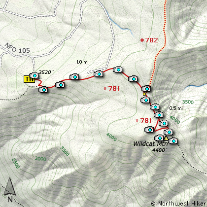
Map of the Wild Cat Mountain Hike
|
Length: 3.5 mi RT
Elevation Change: 961' gain
Season: Late Spring thru Fall
Difficulty: Challenging
Permit: NW Forest Pass Required
Features:
NEW!
Click for PDF Topo Map of this Hike
There are two basic and common ways to hike to the top of Wildcat Mountain. One is to
follow McIntyre Ridge Hike 62 from the East Wildcat Mountain Road trailhead off US 26 for approximately
5.25 miles, and the other is from Wildcat Mountain Drive trailhead off Hwy 224 between Eagle Creek and Estacada. This
description illustrates the shorter hike.
The hike begins in what appears to be an old rock quarry, and I didn't see any signs or indications that I was
in the right place. But there is an obvious trail, so I followed it and behold, it was the correct choice. Be
aware that a very short distance away is a shooting range, so you are likely to hike to the tune of rifle, pistol,
and small cannon fire as you try to enjoy the extraordinary beauty of this hike.
The trail begins in a young dense forested area, but within a quarter mile it breaks out onto an open cliffy area,
and you have great views to the southeast toward Old Baldy, Tumala Mountain, and Wildcat Mountain itself. This view
area is brief, and soon you will spend most of the next mile in dense new forest. The trail doesn't climb very
steeply, but steadily. At about a mile you will come to the junction of the trail from McIntyre Ridge, which is
the other popular route to Wildcat Mountain. Just keep straight ahead, as the trail now becomes noticeably steeper.
The trail offers a couple of options as you climb up the north side of Wildcat. I always choose any option
that takes me to the left (north), because from this route you get exhilarating views of the Cascade Mountains,
including Mt. St. Helens, Mt. Rainier, Mt. Adams, and nearby Mt. Hood.
There once was a fire lookout on top of Wildcat Mountain, but since its removal, the trees on top have grown
considerably. Therefore there isn't a good view in any direction from the actual top of the mountain. So,
when you get there, just walk across the top and through the trees to the south side of the peak, and you will
be treated to great views, including Mt. Jefferson.

Mt. Hood from the summit of Wilcat Mountain
|
How to get there:
NEW!
Click for PDF Directions Map of this Hike
To reach the trailhead to Wildcat Mountain from the Portland, Oregon area,
follow State Hwy 224 from Clackamas toward Estacada. About a mile past the
intersection of Hwy 224 and Hwy 211 you will come to Wildcat Mountain Drive.
At about 13 miles Wildcat Mountain Drive enters the National Forest and
turns into Forest Road 36. Then in a couple of miles the road changes names
again to Forest Road 3626. Continue for another half mile to Forest Road #105.
Turn right on FR 105 and follow it a short distance to Forest Road #150.
Bear right on FR 150 and follow it to the rock quarry. The trail begins at
the east side of the quarry. It was unmarked the day I hiked it, but obvious.
|
|
|
A Virtual Hike of the Mount Hood National Forest


|
|


