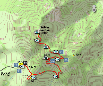
Length: 5.5 miles round trip
Elevation Change: 1603' gain
Season: Spring thru Fall
Difficulty: Challenging
Permit: No Pass Required
Features:
Here is a real gem of a hike that you will
not regret taking the time to get there.
The trail head is a few miles off US 26
just a bit east of the junction of Oregon
Hwy 53 and US 26.
Saddle Mtn Hike is an awesome little stroll
up a rather steep rocky outcropping locate
in the northwestern corner of the state of
Oregon. In the spring, usually during the
month of May, the wildflowers along this
hike are just spectacular.
The trail is excellent and well maintained.
There are flush toilet restrooms at the
trailhead and several picnic tables.
Even though the trail is rather steep at
times, for the most part it is well switch
backed and offers good footing. There are
three picnic tables strategically placed
along the trail as you make the ascent. As you
climb to the top of Saddle Mountain, the
views just get better and better.
From the summit you get a fabulous 360 degree
view ranging from the Pacific Ocean to the west
to Mt Rainier, Mt St Helens, Mt Hood, and
Mt Jefferson.
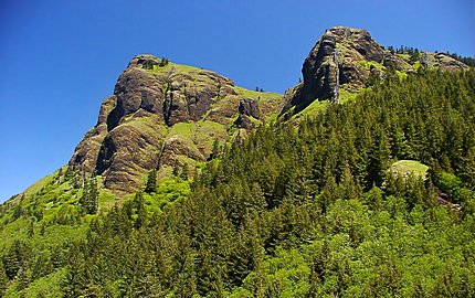
Saddle Mountain
|