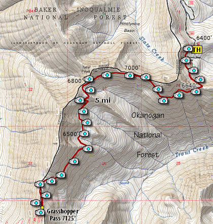
Length: 10 mile RT
Elevation Change: 1700' cumulative elevation gain
Season: Summer thru Fall
Difficulty: Challenging
Permit: NWF Pass Required
Features:
Grasshooper Pass hike begins at a trailhead along the Pacific
Crest Trail just south of Hart's Pass. The entire hike is on
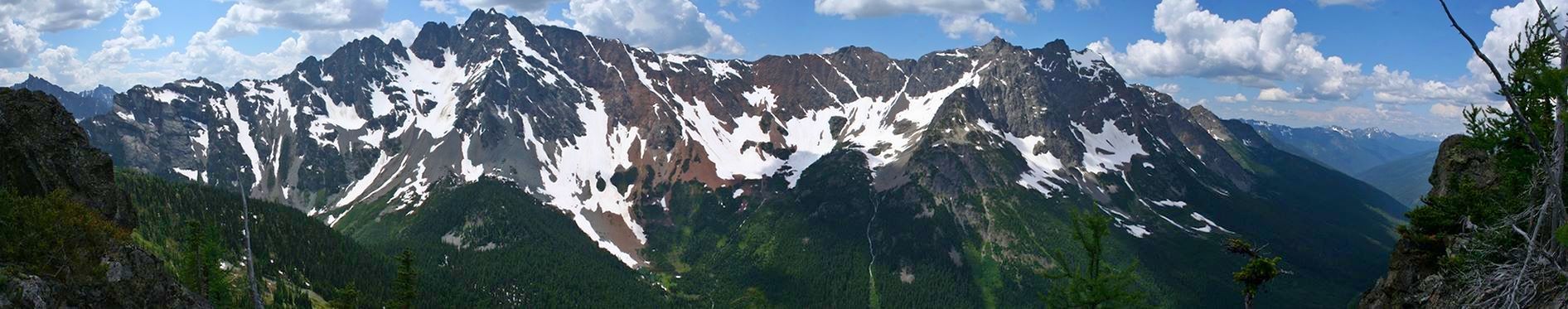
the PCT and offers some of the very best vistas of the northern
Cascade Mountains.
This is a particularily rewarding hike in that not only is the
hiker surrounded by world class mountain vistas, but the hike
itself is relatively easy. I say relatively, because I label
this hike as challenging, but for a ten miler in the middle of
the northern Cascades, this is a very comfortable hike.
The hike is almost entirely out in the open and along various
ridgelines and across various meadows and snowfields. There is
a considerable amount of up and down, but the total elevation
gain for the entire trip, out and back, is only about 1700'.
This is a high elevation hike and the trees are mostly mountain
hemlock, fir, and larch. In late July and early August, the
mountain wildflowers are abundant, but so are the snow fields.
Take plenty of water with you just in case the snow isn't
providing the various creeks with run-off, but most likely it
won't be a problem until late summer.
From the trailhead to Grasshopper Pass is about 5 miles. At about
two miles the trail reachs the easter ridgeline of Tatie Peak, which
if you have the time would be worthwhile scramble of only four
hundred feet. Here you are standing on a ridge that divides the
Slate Creek drainage to the north from the Trout Creek drainage to
the south. At two and a half miles, the trail comes to another
ridgeline which looks north into the South Slate Creek drainage. This
entire hike from trailhead to Grasshopper Pass is mostly along a
divide between the Slate Creek drainage to the north and the Trout
Creek drainage to the south and east.
I hiked this wonderful hike in the middle of August and near the
end I walked over a lot of snow. So, be prepared for and adventure
that you will not likely forget.
|