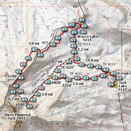
Length: 9.3 mile loop
Elevation Change: 2400' cumulative elevation gain
Season: Summer thru Fall
Difficulty: Difficult
Permit: NWF Pass Required
Features:
This is one of the most rewarding hikes in the central Oregon
Cascades. Because I present this hike as a loop, means that
there is a lot of climbing and descending then re-climbing.
Nevertheless, all in all the hike is extremely rewarding.
Just don't be in a big hurry, unless you are being followed
by several squadrons of mosquitos.
Because this is a loop hike, obviously you can decide which
way to hike the loop; clock-wise or counter clock-wise. I
have done it both ways, and I feel that for the best photos,
one should do this hike clock-wise.
But, even then, you get yet another option. You could hike
toward Wasco lake for a mile, then turn left and head to the
base of Three Fingered Jack. As a photographer, I think this
may be the best option for morning photos of the creek and
the mountain meadows along the way.
However you end up at the base of Three Fingered Jack, be
aware that there is NO designated trail up the moraine, or
eventually across the morain to meet up with the Pacific
Crest Trail in order to complete the loop.
However, at this elevation you are mostly out in the open,
so you can "see" where it is you are going or want to go.
So, navigation should not be a problem. Nevertheless, I
do not accept responsibility for your personal navigation
skills and therefore be prepared to do your off-trail hiking
at your own risk.
Once on the PCT, the hike is mostly down hill to Minto Pass,
and to Wasco Lake. But, once you reach the lake, you will have to
climb in order to cross the ridge to Jack Lake and your vehicle.
This is a world class hike and I hope you feel that way after
you have completed this adventure.... Enjoy!

Three Fingered Jack from Canyon Creek Meadows
|