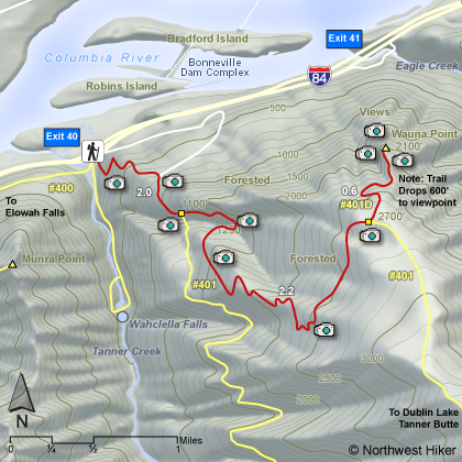
Length: 10 miles round trip
Elevation Change: 3380' gain
Season: Late Spring thru Fall
Difficulty: Difficult
Permit: NW Forest Pass Required
Features:
This hike begins at the Wahclella Falls parking lot. Just walk a brief
distance back toward the freeway and you will see the trail on your right taking off up
behind the parking lot. Follow the trail for about a mile and after crossing under power
lines you will come to a service road which you need to follow south upstream for about
another mile. You will then come to the Tanner Ridge/Butte Trail head.
Follow Trail #401
for about 2.2 miles and 1500' in elevation later you will come to a junction with the
Wauna Point Trail #401D. Bear to your left and follow the UN-MAINTAINED trail through thick
forest toward the Columbia River Gorge. In about a half mile the trail splits, and if
you really want to walk out onto Wauna Point, take the left fork of the trail. The
trail now really deteriorates.
Carefully negotiate the obstacle course before you and
work your way down, and down, and down the slope until you finally reach Wauna Point.
Oh, yeah, you'll know when you've arrived... one more step and you'll be back at your
car. The return trip, of course, required that you climb back up the steep slopes you
just descended. But, hey, you're a hiker, and it's worth it!!!
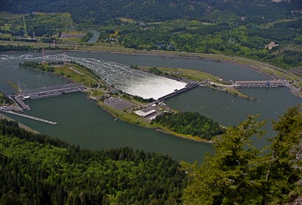 Bonneville Dam from Wauna Point
|
|
How to get there:
Wahclella Falls/Toothrock Trailhead: From I-84, take Exit #40/Bonneville Dam. Turn south at
the stop sign and drive about 100 feet. Stay to the right, taking you to Wahclella Falls trailhead.
Left takes you to Toothrock trailhead.
As with Munra Point, you need to walk back towards the freeway to the road that heads east to the
Toothrock Trailhead. Just as you begin to walk in that direction, you will see the trailhead
sign to Tanner Butte, which is the trail you need to get to Wauna Point.
|