Length: 17.0 miles round trip
Elevation Change: 4500' gain
Season: Summer thru early Fall until snowfall
Difficulty: Very Difficult due to length of hike and elevation gained
Permit: NW Forest Pass Required
Features:
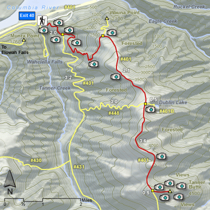
This is a long hike with lots of elevation gain. There is only one water
source along the way of any significance. The hike starts at the Wahclella Falls trail head,
but not the Wahclella Falls trail.
Walk back toward the freeway, and you will see a trail
taking off above the parking lot area.
You will walk about a mile when you will come out
on a service road. Walk the service road south for about another mile and you will come
to the Tanner Ridge/Butte trail head sign.
At this point there are a series of nice
waterfalls as you begin you climb up Tanner Ridge. Follow Trail #401 for a little over
two miles, and you will come to the junction of Trail #401D to Wauna Point. Keep right and continue the climb up Tanner
Ridge. In another couple of miles you will come to the junction of Trail #448 which leads
back down the canyon toward Tanner Creek and back out to where you began this journey.
Continue on a brief distance and you come to the junction to Dublin Lake. The lake is
about a half mile down a very steep grade.
However, as you continue toward Tanner
Butte, you will eventually come to an abandoned road which the trail follows nearly
the balance of the hike. Finally you will come out into some open areas and begin to
experience some viewpoints, one of which is of Tanner Butte itself. This trail you
are on actually continues all the way down to Eagle Creek, but you will come to a
cutoff trail to the top of Tanner Butte. It is well marked, but the trail isn't.
The views from Tanner Butte on a clear day make this long hike worth it.
 Tanner Butte
|
|
How to get there:
Wahclella Falls/Toothrock Trailhead: From I-84, take Exit #40/Bonneville Dam. Turn south at
the stop sign and drive about 100 feet. Stay to the right, taking you to Wahclella Falls trailhead.
Left takes you to Toothrock trailhead.
As with Munra Point, you need to walk back towards the freeway to the road that heads east to the
Toothrock Trailhead. Just as you begin to walk in that direction, you will see the trailhead
sign to Tanner Butte (and Dublin Lake).
|