Hike 50
The Columbia River Gorge National Scenic Area
Wygant Peak Hike
Search West Hikes West Central East Central East Hikes
Home Page
Main Map


Click to view product details

THE FOLLOWING MAP IS NOT TO BE USED FOR NAVIGATIONAL PURPOSES. Wygant Peak Hike map
Map of Wygant Peak Hike

Length: 8 miles round trip loop
Elevation Change: 2000' gain
Season: Early Spring thru Early Winter
Difficulty:    Challenging due to elevation gain and length of hike
Permit:   No Pass Required
GPS:   N45 42.1872 W121 37.1154
Latitude:   45.70312
Longitude:   -121.61859
Features:


NEW!
 Click for PDF Topo Map of this Hike 

Beginning at Lausmann State Park Picnic Area, this hike is a nice forested hike with an occasional view of the gorge from various outcroppings along the way.

In the spring this hike has many beautiful floral displays and small streams to enjoy. The summit is a bit disappointing in that it is located in dense forest with no view.

Be aware that this trail runs through an extraordinary amount of poison oak.


Columbia River Gorge from the Wygant Peak trail

How to get there:

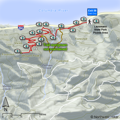
Mitchell Point Trailhead: Traveling east on I-84, take Exit #58/Mitchell Point Overlook (eastbound exit only).

Traveling west on I-84, continue past Exit #58/Mitchell Point Overlook to Exit #56/Viento. Turn around here and head east.


Hike Difficulty Calculator

Calorie Burn Calculator

The 10 Essentials
Bear Encounters

Cougar Encounters

River Crossing Safety
A Virtual Hike of the Columbia River Gorge National Scenic Area


Click to View Instructions
e="NW Hiker is now available in APP for your Android. It is available for download at the Google APP Store. Click on this banner for more details." />