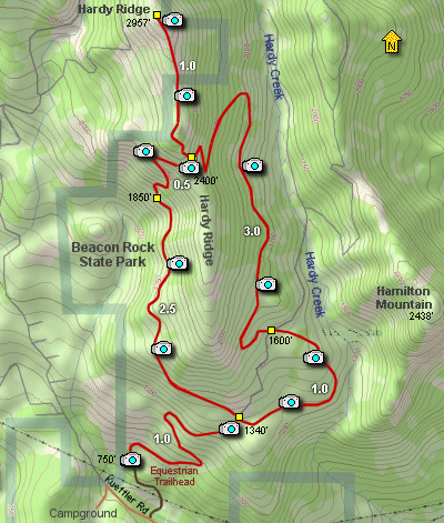
Length: 10 mile loop
Elevation Change: 2500 feet approx.
Season: Almost Year Round
Difficulty: Difficult
Permit: Washington State Day - Pass Required
GPS: N45 38.4528, W122 1.9338
Latitude: 45.64088
Longitude: -122.03223
Features:
This is a fairly newly constructed trail that uses both equestrian and foot
trail portions to reach the highest point of Hardy Ridge.
This hike is located within the Beacon Rock State Park, and is accessable via
Kueffler Road, which is just west of the Beacon Rock parking area on Hwy 14.
Follow Kueffler Road uphill until you see the Equestrian Trailhead sign, and
turn onto this road which leads to the trailhead.
The hike begins at the newly developed trailhead, complete with new restroom
facilities. For the first few miles, the trail follows an old roadbed, which
makes the hike conversational... in that you can walk beside a friend and chat.
The hike is presented as a loop and I will describe it going clock-wise.
At the first junction, bear a steep left and continue along an old roadbed.
However the trail will begin to look more like a trail than a roadbed as it
climbs up the western flank of Hardy Ridge.
At about the three mile mark, the trail suddenly leaves any resemblance to an
old road bed and climbs like a home sick angel. Better have strong legs and
lots of water, cause this is aerobic indeed.
In about a half mile the trail comes to a junction. Bear to the left at this
point, but upon return, bear once again to the left and head down the east side
of Hardy Ridge.
The trail now climbs steeply along the ridgeline of the moutain and views
become more and more frequent. The summit is a steep rocky outcropping and
can be seen over a half mile away as you follow the ever more challenging
trail.
The rewards are well worth the sweat and tears it may take you to get to the
top. In season the wildflowers are abundant. In all seasons the views are
terrific.
Returning, head back to the junction described ealier, and bear left, heading
down the east side of Hardy Ridge. Soon you will be walking on another old
roadbed, which will take you all the way back to your starting place.
The equestrian trail is actually shorter than the foot trail, but you can use
either.
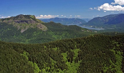 Looking east toward Table Mountain from Hardy Ridge
|